Geographic Region: SPAIN
Feature: MADRID, CENTRO,CASA DE CAMPO, MANZANARES R.
|
Geographic Region: SPAIN Feature: MADRID, CENTRO,CASA DE CAMPO, MANZANARES R. |
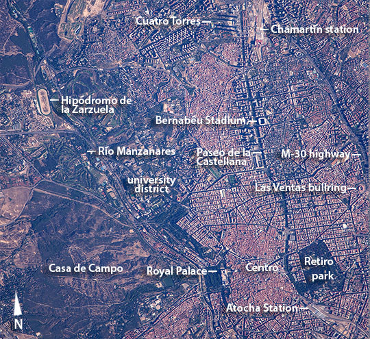 |
| Central Madrid, Spain With the most powerful lens aboard the International Space Station, an astronaut photographed the center of Madrid in the early morning sun. This fraction of the metropolitan area (population of about 6.5 million) shows numerous famous places that can be seen from space. The Manzanares River crosses the entire left side of the view (image top left to lower center), with the largest city park on its west (Casa de Campo) and the ancient center of Madrid, known as the Centro district (at image lower right) on the other bank. Seen from space, the river is less prominent than the very wide, tree-lined triple thoroughfare known as the Paseo de la Castellana. This avenue crosses the entire image (a distance of ~9 km) and leads north from Madrid's largest Atocha railway station (at image lower right), along one side of the Centro district (at image lower right), to the other major railway station known as Madrid Chamartin (at image top right). The famous football (soccer) stadium of Santiago Bernabeu, home to the Real Madrid soccer club, lies on this major paseo. The business center known as the Cuatro Torres (Four Towers) also lies on this avenue (at image top center)--the long, straight shadows of the four towers stand out markedly in this early morning image. Madrid displays a modern infrastructure--such as the M-30 highway at image top right--but it has managed to preserve its historic neighborhoods and streets, especially in the Centro district where the ancient street pattern of small, irregular city blocks contrasts with bigger blocks and straighter streets in younger surrounding neighborhoods. Landmarks in and around the Centro district include the Royal Palace of Madrid, a great square building with one of the largest footprints in the city, lying next to the city's main cathedral. The district also houses the Royal Theatre, a large number of famous art museums, and the National Library. Further east near the M-30 highway lies the circular Las Ventas bullring (at image far right), considered by many to be the world center of bull fighting. Madrid is known as one of the most livable cities in the world. This is partly due to the green, wooded spaces that show up so clearly in this image, especially the woodlands along the Manzanares River known as the Casa de Campo (at image lower left). This enormous urban parkland stretches from the city center for kilometers to the west. It is Madrid's so-called "green lung" and is the largest urban park in Spain. Also part of the green zone is the spacious university district where several institutions of higher learning are located (at image center left). Madrid hosts some of the oldest universities in the world. The racecourse, the Hipodromo de la Zarzuela, is also located in this green zone. Madrid is the political, economic and cultural center of Spain. It is the third-largest city in the European Union, after London and Berlin, and its metropolitan area is the third-largest in the European Union after London and Paris. |
| Images: | All Available Images Low-Resolution 267k |
|
| Mission: | ISS045 |
|
| Roll - Frame: | E - 15741 |
|
| Geographical Name: | SPAIN |
|
| Features: | MADRID, CENTRO,CASA DE CAMPO, MANZANARES R. |
|
| Center Lat x Lon: | 40.5N x 3.7W |
|
| Film Exposure: | N=Normal exposure, U=Under exposed, O=Over exposed, F=out of Focus |
|
| Percentage of Cloud Cover-CLDP: | 10 |
|
| Camera:: | N6 |
|
| Camera Tilt: | 27 | LO=Low Oblique, HO=High Oblique, NV=Near Vertical |
| Camera Focal Length: | 1150 |
|
| Nadir to Photo Center Direction: | W | The direction from the nadir to the center point, N=North, S=South, E=East, W=West |
| Stereo?: | Y=Yes there is an adjacent picture of the same area, N=No there isn't |
|
| Orbit Number: | |
|
| Date: | 20150918 | YYYYMMDD |
| Time: | 080202 | GMT HHMMSS |
| Nadir Lat: | 41.2N |
Latitude of suborbital point of spacecraft |
| Nadir Lon: | 2W |
Longitude of suborbital point of spacecraft |
| Sun Azimuth: | 109 | Clockwise angle in degrees from north to the sun measured at the nadir point |
| Space Craft Altitude: | 217 | nautical miles |
| Sun Elevation: | 24 | Angle in degrees between the horizon and the sun, measured at the nadir point |
| Land Views: | |
|
| Water Views: | RIVER |
|
| Atmosphere Views: | |
|
| Man Made Views: | HIGHWAY, UNIVERSITY |
|
| City Views: | MADRID |
|
Photo is not associated with any sequences | ||
| NASA Home Page |
JSC Home Page |
JSC Digital Image Collection |
Earth Science & Remote Sensing |
|
This service is provided by the International Space Station program and the JSC Earth Science & Remote Sensing Unit, ARES Division, Exploration Integration Science Directorate.

|