
Geographic Region: ISRAEL
Feature: HAIFA AT NIGHT
|
Geographic Region: ISRAEL Feature: HAIFA AT NIGHT |
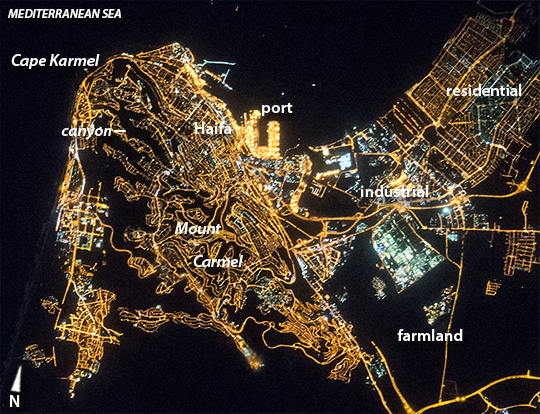 |
| The city of Haifa in daylight and at night Part of the astronaut experience is recognizing--and then photographing--the same place under completely different conditions, in daylight and at night. Astronauts become adept at merging both visions of the planet. The same astronaut probably took both these day and night images (with similar lenses) of the port city of Haifa on Israel's Mediterranean coast. In geography training astronauts are taught to concentrate on the shapes of coastlines because they are first-order visual cue when circling the planet, and often uniquely shaped. The nose of Cape Karmel (image top left) and the bay that protects the Port of Haifa (image upper center) are shapes that can tell crews where they are, especially after they have been in space for a few weeks. In the daylight image (ISS046-E-1292)the strong visual line of the coast contrasts with the subtle city colors. The steep slope of the north flank of Mount Carmel, facing the port, is marked by a long dark shadow in the midafternoon sun. Shorter shadows indicate several steep-sided canyons that cut into Mount Carmel (image left). Older neighborhoods with linear roads lie on the lower slopes nearer the port. Newer neighborhoods show a pattern of streets that wind along the intricate edges of the canyons. This distinction is best seen in the night image. In a small country where land is scarce, brown farmlands can be seen close to the middle of the city. The night shot does not show the coastline, unless you know where to look for it. But it does show different city neighborhoods in a way that is difficult to see in the day. The brilliant port lights contrast with the surrounding less bright residential areas. Straight roads of the older residential neighborhoods are easily distinguished from the winding roads that follow the canyon cliffs. The industrial area just east of the port has areas of green and blue lights and a less dense street pattern. Surrounding farmlands are so dark that they can be confused with the sea. |
| Images: | All Available Images Low-Resolution 368k |
|
| Mission: | ISS045 |
|
| Roll - Frame: | E - 148262 |
|
| Geographical Name: | ISRAEL |
|
| Features: | HAIFA AT NIGHT |
|
| Center Lat x Lon: | 32.7N x 35.0E |
|
| Film Exposure: | N=Normal exposure, U=Under exposed, O=Over exposed, F=out of Focus |
|
| Percentage of Cloud Cover-CLDP: | 10 |
|
| Camera:: | N6 |
|
| Camera Tilt: | HO | LO=Low Oblique, HO=High Oblique, NV=Near Vertical |
| Camera Focal Length: | 400 |
|
| Nadir to Photo Center Direction: | NW | The direction from the nadir to the center point, N=North, S=South, E=East, W=West |
| Stereo?: | Y=Yes there is an adjacent picture of the same area, N=No there isn't |
|
| Orbit Number: | |
|
| Date: | 20151129 | YYYYMMDD |
| Time: | 015322 | GMT HHMMSS |
| Nadir Lat: | 22.0N |
Latitude of suborbital point of spacecraft |
| Nadir Lon: | 46.6E |
Longitude of suborbital point of spacecraft |
| Sun Azimuth: | 106 | Clockwise angle in degrees from north to the sun measured at the nadir point |
| Space Craft Altitude: | 213 | nautical miles |
| Sun Elevation: | -18 | Angle in degrees between the horizon and the sun, measured at the nadir point |
| Land Views: | CAPE, COAST |
|
| Water Views: | BAY, SEA |
|
| Atmosphere Views: | |
|
| Man Made Views: | PORT |
|
| City Views: | HAIFA |
|
Photo is not associated with any sequences | ||
| NASA Home Page |
JSC Home Page |
JSC Digital Image Collection |
Earth Science & Remote Sensing |
|
This service is provided by the International Space Station program and the JSC Earth Science & Remote Sensing Unit, ARES Division, Exploration Integration Science Directorate.

|