Geographic Region: ZAMBIA
Feature: LAKE WALILUPE, LACUSTRINE MARSHES, POND, ROADS, VILLAGES, DRAINAGE
|
Geographic Region: ZAMBIA Feature: LAKE WALILUPE, LACUSTRINE MARSHES, POND, ROADS, VILLAGES, DRAINAGE |
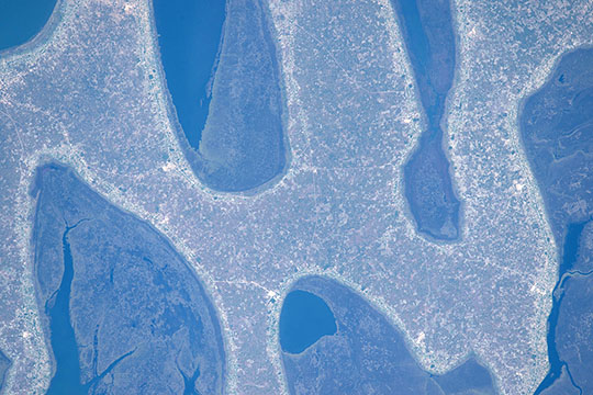 |
| Chilubi Island, Lake Bangweulu, Zambia Astronauts aboard the International Space Station took this detailed image of the strange rounded shapes of the coastline of Chilubi Island, a light-toned island of sand in the dark waters of Lake Bangweulu. Here we see open water in the arms of the lake with areas of wetland vegetated (reed, papyrus and floating grass) in green. The coastlines are smoothed by easterly winds eroding ancient sand dunes. Chilubi Island has 100 km of coastline giving prime access to the richest fishing waters in northern Zambia. The higher population density of numerous fishing villages has resulted in a narrow devegetated strip of a lighter tone following all the shorelines. The lake, which is only 4 m deep on average, is rich enough to supply fish for the copper-mining towns to the west. The explorer and missionary David Livingstone was the first European to visit the lake (1868). |
| Images: | All Available Images Low-Resolution 101k |
|
| Mission: | ISS044 |
|
| Roll - Frame: | E - 661 |
|
| Geographical Name: | ZAMBIA |
|
| Features: | LAKE WALILUPE, LACUSTRINE MARSHES, POND, ROADS, VILLAGES, DRAINAGE |
|
| Center Lat x Lon: | 11.2S x 30.0E |
|
| Film Exposure: | N=Normal exposure, U=Under exposed, O=Over exposed, F=out of Focus |
|
| Percentage of Cloud Cover-CLDP: | 10 |
|
| Camera:: | N6 |
|
| Camera Tilt: | 13 | LO=Low Oblique, HO=High Oblique, NV=Near Vertical |
| Camera Focal Length: | 1150 |
|
| Nadir to Photo Center Direction: | SE | The direction from the nadir to the center point, N=North, S=South, E=East, W=West |
| Stereo?: | Y=Yes there is an adjacent picture of the same area, N=No there isn't |
|
| Orbit Number: | |
|
| Date: | 20150614 | YYYYMMDD |
| Time: | 102945 | GMT HHMMSS |
| Nadir Lat: | 10.5S |
Latitude of suborbital point of spacecraft |
| Nadir Lon: | 29.5E |
Longitude of suborbital point of spacecraft |
| Sun Azimuth: | 349 | Clockwise angle in degrees from north to the sun measured at the nadir point |
| Space Craft Altitude: | 217 | nautical miles |
| Sun Elevation: | 56 | Angle in degrees between the horizon and the sun, measured at the nadir point |
| Land Views: | ISLAND |
|
| Water Views: | LAKE |
|
| Atmosphere Views: | |
|
| Man Made Views: | |
|
| City Views: | |
|
Photo is not associated with any sequences | ||
| NASA Home Page |
JSC Home Page |
JSC Digital Image Collection |
Earth Science & Remote Sensing |
|
This service is provided by the International Space Station program and the JSC Earth Science & Remote Sensing Unit, ARES Division, Exploration Integration Science Directorate.

|