
Geographic Region: USA-MASSACHUSETTS
Feature: C. COD, PROVINCETOWN
|
Geographic Region: USA-MASSACHUSETTS Feature: C. COD, PROVINCETOWN |
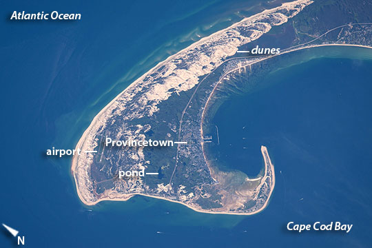 |
| Cape Cod, Massachusetts Astronauts aboard the International Space Station used a very long lens to shoot this detailed image of the northern tip of Cape Cod--showing 8.5 miles (14 km) of its 65-mile (105 km) length. Cape Cod is one of the biggest barrier islands in the world, and it protects towns like Provincetown and its port facilities (image center) from storm waves coming in from the Atlantic Ocean. It thus also protects much of the Massachusetts coastline. The cream-colored features are symmetrically shaped dunes built mainly by northwesterly winter winds (image upper center) blowing beach sands inland. In terms of geological age, Cape Cod is young, having been laid down about 20,000 years ago by glaciers when these were at their fullest extent. Even though Cape Cod today has water on both sides, it consists of moraine and associated river deposits laid down by two large lobes of ice that extended into the area from Canada (i.e, out of the image upper left). Strange as it seems today, one great ice lobe lay to the seaward side of the cape, and another on the Cape Cod Bay side. Many ponds (image center) remain on Cape Cod as a result of the receding glacier (image center). Why is the cape shaped the way it is? When the glaciers were at their fullest extent sea level was more than one hundred meters (more than 325 feet) lower than it is today--because so much water was bound up in huge continental ice sheets. As the ice melted, sea level kept rising and areas that had been covered by ice were submerged under the rising Atlantic waters. At this point waves and sea currents started to erode the moraines and river deposits of the cape. Because it juts out into the Atlantic Ocean, the cape shoreline is heavily eroded by waves. Sometimes the ocean breaks through the barrier island as happened during Hurricane Bob in 1991. In this image, the strong wave erosion has smoothed the beachline facing the Atlantic Ocean. The sands eroded by the waves have been swept northward to feed the growth of the cape. When a sandy coastal spit like Cape Cod advances into deeper water it grows more slowly and wave action starts to bend the line of spit growth inshore. In the extreme case of Cape Cod, this wave refraction around the tip has turned the growth direction progressively to the west, and then to the south (image lower left and image bottom respectively)--forming the hook shape we see today. |
| Images: | All Available Images Low-Resolution 75k |
|
| Mission: | ISS044 |
|
| Roll - Frame: | E - 610 |
|
| Geographical Name: | USA-MASSACHUSETTS |
|
| Features: | C. COD, PROVINCETOWN |
|
| Center Lat x Lon: | 42.1N x 70.2W |
|
| Film Exposure: | N=Normal exposure, U=Under exposed, O=Over exposed, F=out of Focus |
|
| Percentage of Cloud Cover-CLDP: | 10 |
|
| Camera:: | N6 |
|
| Camera Tilt: | 23 | LO=Low Oblique, HO=High Oblique, NV=Near Vertical |
| Camera Focal Length: | 1150 |
|
| Nadir to Photo Center Direction: | W | The direction from the nadir to the center point, N=North, S=South, E=East, W=West |
| Stereo?: | Y=Yes there is an adjacent picture of the same area, N=No there isn't |
|
| Orbit Number: | |
|
| Date: | 20150613 | YYYYMMDD |
| Time: | 205544 | GMT HHMMSS |
| Nadir Lat: | 42.6N |
Latitude of suborbital point of spacecraft |
| Nadir Lon: | 68.8W |
Longitude of suborbital point of spacecraft |
| Sun Azimuth: | 272 | Clockwise angle in degrees from north to the sun measured at the nadir point |
| Space Craft Altitude: | 212 | nautical miles |
| Sun Elevation: | 33 | Angle in degrees between the horizon and the sun, measured at the nadir point |
| Land Views: | CAPE, EROSION |
|
| Water Views: | BAY, OCEAN, SEA, WAVE |
|
| Atmosphere Views: | |
|
| Man Made Views: | PORT |
|
| City Views: | |
|
Photo is not associated with any sequences | ||
| NASA Home Page |
JSC Home Page |
JSC Digital Image Collection |
Earth Science & Remote Sensing |
|
This service is provided by the International Space Station program and the JSC Earth Science & Remote Sensing Unit, ARES Division, Exploration Integration Science Directorate.

|