
Geographic Region: USA-TEXAS
Feature: PAN TEXAS & N. MEXICO AT NIGHT, SPRITE
|
Geographic Region: USA-TEXAS Feature: PAN TEXAS & N. MEXICO AT NIGHT, SPRITE |
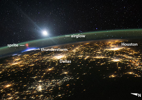 |
| Red Sprites Above the U.S. and Central America Viewing from a point over northwest Mexico, astronauts aboard the International Space Station looked northeast and shot this unusual photograph of a red sprite above the white light of an active thunderstorm (image top left). The sprite was 2,200 kilometers (1,400 miles) away, high over Missouri or Illinois; the lights of Dallas, Texas appear in the foreground. The sprite shoots up to the greenish airglow layer, near a rising moon. These photos show the sprite's tendrils reaching as much as 100 kilometers above Earth's surface. Sprites are major electrical discharges, but they are not lightning in the usual sense. Instead, they are a cold plasma phenomenon without the extremely hot temperatures of lightning that we see underneath thunderstorms. Red sprites are more like the discharge of a fluorescent tube. Bursts of sprite energy are thought to occur during most large thunderstorm events. They were first photographed in 1989. |
| Images: | All Available Images Low-Resolution 101k |
|
| Mission: | ISS044 |
|
| Roll - Frame: | E - 45553 |
|
| Geographical Name: | USA-TEXAS |
|
| Features: | PAN TEXAS & N. MEXICO AT NIGHT, SPRITE |
|
| Center Lat x Lon: | 31.5N x 99.5W |
|
| Film Exposure: | N=Normal exposure, U=Under exposed, O=Over exposed, F=out of Focus |
|
| Percentage of Cloud Cover-CLDP: | 10 |
|
| Camera:: | N6 |
|
| Camera Tilt: | HO | LO=Low Oblique, HO=High Oblique, NV=Near Vertical |
| Camera Focal Length: | 28 |
|
| Nadir to Photo Center Direction: | E | The direction from the nadir to the center point, N=North, S=South, E=East, W=West |
| Stereo?: | Y=Yes there is an adjacent picture of the same area, N=No there isn't |
|
| Orbit Number: | |
|
| Date: | 20150810 | YYYYMMDD |
| Time: | 075851 | GMT HHMMSS |
| Nadir Lat: | 28.2N |
Latitude of suborbital point of spacecraft |
| Nadir Lon: | 109.4W |
Longitude of suborbital point of spacecraft |
| Sun Azimuth: | 12 | Clockwise angle in degrees from north to the sun measured at the nadir point |
| Space Craft Altitude: | 215 | nautical miles |
| Sun Elevation: | -46 | Angle in degrees between the horizon and the sun, measured at the nadir point |
| Land Views: | MOON |
|
| Water Views: | |
|
| Atmosphere Views: | THUNDERSTORM |
|
| Man Made Views: | |
|
| City Views: | DALLAS |
|
Photo is not associated with any sequences | ||
| NASA Home Page |
JSC Home Page |
JSC Digital Image Collection |
Earth Science & Remote Sensing |
|
This service is provided by the International Space Station program and the JSC Earth Science & Remote Sensing Unit, ARES Division, Exploration Integration Science Directorate.

|