Geographic Region: MADAGASCAR
Feature: LINTA R. DELTA, DUNES, REEFS, MANGROVE
|
Geographic Region: MADAGASCAR Feature: LINTA R. DELTA, DUNES, REEFS, MANGROVE |
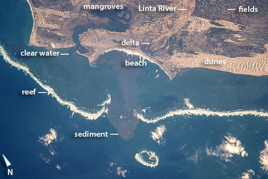 |
| Linta River delta and dunes, southern Madagascar Astronauts aboard the International Space Station used a very long lens to shoot this detailed image of the remote Linta River delta zone in southern Madagascar--showing 7.5 miles (12.1 km) of complex shoreline. Waves break far offshore (1.4 mi, 2.25 km) against a long line of coral reefs. A gap in the reef opposite the delta indicates where the river flowed at times of low sea level when the shoreline was far to the southwest of its present position, crossing the lower left corner of the image. Bright, light-toned dunes cast shadows in the late afternoon sun. These winds build sand dunes by blowing sand out of the Linta River bed (image upper left). The bigger dune field (image upper right) is fed by sand moving from another delta out of the picture right. Just inland, numerous agricultural blocky fields occupy earlier dune fields (image far top right). |
| Images: | All Available Images Low-Resolution 96k |
|
| Mission: | ISS044 |
|
| Roll - Frame: | E - 27240 |
|
| Geographical Name: | MADAGASCAR |
|
| Features: | LINTA R. DELTA, DUNES, REEFS, MANGROVE |
|
| Center Lat x Lon: | 25S x 44.1E |
|
| Film Exposure: | N=Normal exposure, U=Under exposed, O=Over exposed, F=out of Focus |
|
| Percentage of Cloud Cover-CLDP: | 10 |
|
| Camera:: | N6 |
|
| Camera Tilt: | 04 | LO=Low Oblique, HO=High Oblique, NV=Near Vertical |
| Camera Focal Length: | 1150 |
|
| Nadir to Photo Center Direction: | SW | The direction from the nadir to the center point, N=North, S=South, E=East, W=West |
| Stereo?: | Y=Yes there is an adjacent picture of the same area, N=No there isn't |
|
| Orbit Number: | |
|
| Date: | 20150801 | YYYYMMDD |
| Time: | 132806 | GMT HHMMSS |
| Nadir Lat: | 24.8S |
Latitude of suborbital point of spacecraft |
| Nadir Lon: | 44.3E |
Longitude of suborbital point of spacecraft |
| Sun Azimuth: | 298 | Clockwise angle in degrees from north to the sun measured at the nadir point |
| Space Craft Altitude: | 219 | nautical miles |
| Sun Elevation: | 14 | Angle in degrees between the horizon and the sun, measured at the nadir point |
| Land Views: | DUNE |
|
| Water Views: | BAY, CHANNEL, DELTA, REEF, RIVER, SEA, SEDIMENT |
|
| Atmosphere Views: | |
|
| Man Made Views: | |
|
| City Views: | |
|
Photo is not associated with any sequences | ||
| NASA Home Page |
JSC Home Page |
JSC Digital Image Collection |
Earth Science & Remote Sensing |
|
This service is provided by the International Space Station program and the JSC Earth Science & Remote Sensing Unit, ARES Division, Exploration Integration Science Directorate.

|