
Geographic Region: TUNISIA
Feature: SFAX, PORT FACILITIES, SALT PONDS
|
Geographic Region: TUNISIA Feature: SFAX, PORT FACILITIES, SALT PONDS |
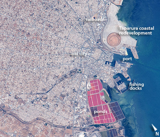 |
| The port of Sfax, Tunisia Astronauts aboard the International Space Station took this detailed image of the radiating street pattern of Tunisia's second city and major port of Sfax (population ~900,000), that also hosts Tunisia's largest fishing fleet (for scale the fishing port is 1.1 km long). The radial street pattern focuses on the ancient walled city (the "medina"--image center) with its distinct pattern as seen from orbit of small blocks and narrow streets, and even a slight color difference of the rooftops. A river winds across the lower left of the image. More detailed visual cues that tell astronauts they are overflying Sfax are the brilliantly colored salt ponds south of the old city and the new circular earth works of the Taparura redevelopment project just north of the old city. Named after the town in antiquity on which Sfax now stands, the redevelopment has reclaimed many hectares along 5 km of shoreline (extending outside the image) and reengineered a polluted and marshy area on the coastal side of the long curve of the city's railroad tracks. |
| Images: | All Available Images Low-Resolution 163k |
|
| Mission: | ISS044 |
|
| Roll - Frame: | E - 1998 |
|
| Geographical Name: | TUNISIA |
|
| Features: | SFAX, PORT FACILITIES, SALT PONDS |
|
| Center Lat x Lon: | 34.7N x 10.8E |
|
| Film Exposure: | N=Normal exposure, U=Under exposed, O=Over exposed, F=out of Focus |
|
| Percentage of Cloud Cover-CLDP: | 10 |
|
| Camera:: | N6 |
|
| Camera Tilt: | 16 | LO=Low Oblique, HO=High Oblique, NV=Near Vertical |
| Camera Focal Length: | 1150 |
|
| Nadir to Photo Center Direction: | S | The direction from the nadir to the center point, N=North, S=South, E=East, W=West |
| Stereo?: | Y=Yes there is an adjacent picture of the same area, N=No there isn't |
|
| Orbit Number: | |
|
| Date: | 20150619 | YYYYMMDD |
| Time: | 123435 | GMT HHMMSS |
| Nadir Lat: | 35.7N |
Latitude of suborbital point of spacecraft |
| Nadir Lon: | 10.7E |
Longitude of suborbital point of spacecraft |
| Sun Azimuth: | 239 | Clockwise angle in degrees from north to the sun measured at the nadir point |
| Space Craft Altitude: | 213 | nautical miles |
| Sun Elevation: | 70 | Angle in degrees between the horizon and the sun, measured at the nadir point |
| Land Views: | |
|
| Water Views: | RIVER |
|
| Atmosphere Views: | |
|
| Man Made Views: | PORT |
|
| City Views: | SFAX |
|
Photo is not associated with any sequences | ||
| NASA Home Page |
JSC Home Page |
JSC Digital Image Collection |
Earth Science & Remote Sensing |
|
This service is provided by the International Space Station program and the JSC Earth Science & Remote Sensing Unit, ARES Division, Exploration Integration Science Directorate.

|