Geographic Region: CHINA
Feature: HIMALAYAS UNDER SNOW
|
Geographic Region: CHINA Feature: HIMALAYAS UNDER SNOW |
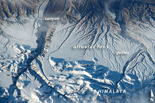 |
| Rivers and snow in the Himalayas This oblique image was taken from the International Space Station as astronauts flew over the Himalaya range in China near the Indian border. The view shows one of the main ranges of the Himalaya Mountains across the bottom of the image, where peaks cast strong evening shadows against the snow. The peaks reach great altitudes (5200 m, 17,000 feet), with those just outside the lower margin reaching high enough (6500 m, 21,325 feet) to host glaciers. Rivers have eroded rock from these high mountains and deposited the sediment as broad alluvial fan surfaces (across the middle of the image). The snow cover shows these strikingly smooth surfaces. A trellis-work of gullies cuts into these surfaces casting sinuous shadows. The largest river in the view has cut a 500 m-deep (1650 foot) canyon through the fans (image left). Although the rivers in the view drain northward from the Himalayas, they ultimately flow back south through the mountain ranges as the Sutlej River (outside the image)--in one of the largest canyons in the world--before entering the lowlands of Pakistan and finally reaching the Arabian Sea. |
| Images: | All Available Images Low-Resolution 141k |
|
| Mission: | ISS043 |
|
| Roll - Frame: | E - 93251 |
|
| Geographical Name: | CHINA |
|
| Features: | HIMALAYAS UNDER SNOW |
|
| Center Lat x Lon: | 31.2N x 79.8E |
|
| Film Exposure: | N=Normal exposure, U=Under exposed, O=Over exposed, F=out of Focus |
|
| Percentage of Cloud Cover-CLDP: | 10 |
|
| Camera:: | N6 |
|
| Camera Tilt: | 39 | LO=Low Oblique, HO=High Oblique, NV=Near Vertical |
| Camera Focal Length: | 500 |
|
| Nadir to Photo Center Direction: | NE | The direction from the nadir to the center point, N=North, S=South, E=East, W=West |
| Stereo?: | Y=Yes there is an adjacent picture of the same area, N=No there isn't |
|
| Orbit Number: | |
|
| Date: | 20150408 | YYYYMMDD |
| Time: | 121251 | GMT HHMMSS |
| Nadir Lat: | 28.8N |
Latitude of suborbital point of spacecraft |
| Nadir Lon: | 78.1E |
Longitude of suborbital point of spacecraft |
| Sun Azimuth: | 272 | Clockwise angle in degrees from north to the sun measured at the nadir point |
| Space Craft Altitude: | 216 | nautical miles |
| Sun Elevation: | 11 | Angle in degrees between the horizon and the sun, measured at the nadir point |
| Land Views: | ALLUVIAL FAN, MOUNTAIN, RANGE |
|
| Water Views: | RIVER |
|
| Atmosphere Views: | |
|
| Man Made Views: | |
|
| City Views: | |
|
Photo is not associated with any sequences | ||
| NASA Home Page |
JSC Home Page |
JSC Digital Image Collection |
Earth Science & Remote Sensing |
|
This service is provided by the International Space Station program and the JSC Earth Science & Remote Sensing Unit, ARES Division, Exploration Integration Science Directorate.

|