
Geographic Region: ARGENTINA
Feature: RIVER PLATE, BUENOS AIRES, SEDIMENT
|
Geographic Region: ARGENTINA Feature: RIVER PLATE, BUENOS AIRES, SEDIMENT |
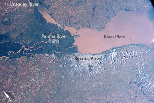 |
| Buenos Aires, River Plate, Argentina This image was taken as astronauts aboard the International Space Station flew over the eye-catching delta and green swamps of the Parana River (image right) on the Atlantic coast of Argentina. The Parana River, South America's second largest after the Amazon River, pours brown muddy water into a wide estuary known as the River Plate (image center and left). The gray mass of Argentina's capital city, Buenos Aires (metro population 12.74 million in 2010), is less prominent seen from space (upper left), although astronauts quickly attune their eyes to the subtle signature of such cityscapes. Numerous small farm plots on red soils surround the delta and city. The muddy river sediment ultimately derives from erosion of the rocks of the Andes Mountains far upstream--mirroring the color of the Amazon River which is also turbid and also rises in the Andes Mountains. In this image tidal backwash transports the muddy water a short distance upstream into the smaller Uruguay River (image lower right). |
| Images: | All Available Images Low-Resolution 109k |
|
| Mission: | ISS043 |
|
| Roll - Frame: | E - 91884 |
|
| Geographical Name: | ARGENTINA |
|
| Features: | RIVER PLATE, BUENOS AIRES, SEDIMENT |
|
| Center Lat x Lon: | 34.5S x 58.5W |
|
| Film Exposure: | N=Normal exposure, U=Under exposed, O=Over exposed, F=out of Focus |
|
| Percentage of Cloud Cover-CLDP: | 10 |
|
| Camera:: | N6 |
|
| Camera Tilt: | 14 | LO=Low Oblique, HO=High Oblique, NV=Near Vertical |
| Camera Focal Length: | 50 |
|
| Nadir to Photo Center Direction: | SE | The direction from the nadir to the center point, N=North, S=South, E=East, W=West |
| Stereo?: | Y=Yes there is an adjacent picture of the same area, N=No there isn't |
|
| Orbit Number: | |
|
| Date: | 20150406 | YYYYMMDD |
| Time: | 181336 | GMT HHMMSS |
| Nadir Lat: | 33.9S |
Latitude of suborbital point of spacecraft |
| Nadir Lon: | 59.2W |
Longitude of suborbital point of spacecraft |
| Sun Azimuth: | 315 | Clockwise angle in degrees from north to the sun measured at the nadir point |
| Space Craft Altitude: | 220 | nautical miles |
| Sun Elevation: | 39 | Angle in degrees between the horizon and the sun, measured at the nadir point |
| Land Views: | COAST |
|
| Water Views: | DELTA, ESTUARY, RIVER, SEDIMENT |
|
| Atmosphere Views: | |
|
| Man Made Views: | |
|
| City Views: | BUENOS AIRES |
|
Photo is not associated with any sequences | ||
| NASA Home Page |
JSC Home Page |
JSC Digital Image Collection |
Earth Science & Remote Sensing |
|
This service is provided by the International Space Station program and the JSC Earth Science & Remote Sensing Unit, ARES Division, Exploration Integration Science Directorate.

|