
Geographic Region: EGYPT
Feature: SUEZ CANAL, PORT SAID, PORT FUAD
|
Geographic Region: EGYPT Feature: SUEZ CANAL, PORT SAID, PORT FUAD |
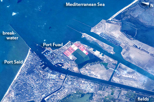 |
| Suez Canal, Port Said, Egypt With a powerful lens, an astronaut aboard the International Space Station photographed the detail of the north end of the Suez Canal, with the city centers and port facilities of Port Said and Port Fuad (image left center). The angular shapes of docks can be seen where local ship traffic can take on and discharge cargo. The long breakwater (image left) protects shipping entering the canal from the prevailing westerly winds and waves. Muddy, light-brown water from the Nile delta (out of the image left) banks up against the west side of the breakwater (left margin of the image). Both ports lie on the west fork of the canal. The east fork (image right) was specifically built to allow ships on long hauls--typically between Europe via the Mediterranean Sea and Asia--to avoid congestion at the west-fork ports. In 2014 Egypt announced plans to dig another canal parallel with the present canal to further ease congestion, because canal tolls provide much needed foreign exchange for Egypt. Present plans however only include a parallel canal covering half the 100 mile (160 km) length of the canal. Other images of the area show the versatility of astronaut photography. More oblique images and shorter lenses give wider views. And images taken looking near the sun's reflection point reveal exotic patterns that show water bodies, water circulation and the highly reflective surfactant films (natural and human oils) that cover sea surfaces. |
| Images: | All Available Images Low-Resolution 124k |
|
| Mission: | ISS043 |
|
| Roll - Frame: | E - 303045 |
|
| Geographical Name: | EGYPT |
|
| Features: | SUEZ CANAL, PORT SAID, PORT FUAD |
|
| Center Lat x Lon: | 31.2N x 32.3E |
|
| Film Exposure: | N=Normal exposure, U=Under exposed, O=Over exposed, F=out of Focus |
|
| Percentage of Cloud Cover-CLDP: | 10 |
|
| Camera:: | N6 |
|
| Camera Tilt: | 37 | LO=Low Oblique, HO=High Oblique, NV=Near Vertical |
| Camera Focal Length: | 1150 |
|
| Nadir to Photo Center Direction: | W | The direction from the nadir to the center point, N=North, S=South, E=East, W=West |
| Stereo?: | Y=Yes there is an adjacent picture of the same area, N=No there isn't |
|
| Orbit Number: | |
|
| Date: | 20150610 | YYYYMMDD |
| Time: | 141216 | GMT HHMMSS |
| Nadir Lat: | 32.0N |
Latitude of suborbital point of spacecraft |
| Nadir Lon: | 34.8E |
Longitude of suborbital point of spacecraft |
| Sun Azimuth: | 280 | Clockwise angle in degrees from north to the sun measured at the nadir point |
| Space Craft Altitude: | 213 | nautical miles |
| Sun Elevation: | 30 | Angle in degrees between the horizon and the sun, measured at the nadir point |
| Land Views: | |
|
| Water Views: | CANAL, DELTA, SEA |
|
| Atmosphere Views: | |
|
| Man Made Views: | PORT |
|
| City Views: | PORT SAID, SUEZ |
|
Photo is not associated with any sequences | ||
| NASA Home Page |
JSC Home Page |
JSC Digital Image Collection |
Earth Science & Remote Sensing |
|
This service is provided by the International Space Station program and the JSC Earth Science & Remote Sensing Unit, ARES Division, Exploration Integration Science Directorate.

|