
Geographic Region: USA-COLORADO
Feature: DENVER,BOULDER, FRONT RANGE,S. PLATTE R.
|
Geographic Region: USA-COLORADO Feature: DENVER,BOULDER, FRONT RANGE,S. PLATTE R. |
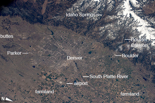 |
| Greater Denver and the Front Range, Colorado Astronauts on board the International Space Station recognized the smooth, broad bend that separates mountains and plains as the Front Range of the Rocky Mountains. This sudden break between plains and mountains makes Denver one of the most spectacular cities in the US. Here canyons cut through the snow-covered mountains to the plains. Boulder Canyon has provided water to the city of Boulder, and tourists exploring the Rocky Mountains pass through Idaho Springs in the Clear Creek valley (image top and top right). The ten urban counties centered on Denver have an estimated population of 2.7 million. The plains fronting the mountains are now heavily populated in a series of cities centered on Denver. The rectangular plat of highways and main roads of this extensive cityscape has a blocky appearance --a pattern that has spread southward more than 25 miles (40 km) to the wooded hills south of the town of Parker (image left). Rich farmland competes with city landuse areas north of Denver in the fertile Platte River valley and surrounding plains (image lower right). This intensively farmed area appears from space as a pattern of numerous smaller plots. Less intensive landuse areas such as spring and winter wheat are marked by much larger plots of land, as seen around Denver's international airport (image lower left). |
| Images: | All Available Images Low-Resolution 117k |
|
| Mission: | ISS043 |
|
| Roll - Frame: | E - 156572 |
|
| Geographical Name: | USA-COLORADO |
|
| Features: | DENVER,BOULDER, FRONT RANGE,S. PLATTE R. |
|
| Center Lat x Lon: | 39.8N x 105.1W |
|
| Film Exposure: | N=Normal exposure, U=Under exposed, O=Over exposed, F=out of Focus |
|
| Percentage of Cloud Cover-CLDP: | 10 |
|
| Camera:: | N6 |
|
| Camera Tilt: | 34 | LO=Low Oblique, HO=High Oblique, NV=Near Vertical |
| Camera Focal Length: | 140 |
|
| Nadir to Photo Center Direction: | NE | The direction from the nadir to the center point, N=North, S=South, E=East, W=West |
| Stereo?: | Y=Yes there is an adjacent picture of the same area, N=No there isn't |
|
| Orbit Number: | |
|
| Date: | 20150429 | YYYYMMDD |
| Time: | 165833 | GMT HHMMSS |
| Nadir Lat: | 38.5N |
Latitude of suborbital point of spacecraft |
| Nadir Lon: | 107.1W |
Longitude of suborbital point of spacecraft |
| Sun Azimuth: | 122 | Clockwise angle in degrees from north to the sun measured at the nadir point |
| Space Craft Altitude: | 214 | nautical miles |
| Sun Elevation: | 53 | Angle in degrees between the horizon and the sun, measured at the nadir point |
| Land Views: | RANGE, VALLEY |
|
| Water Views: | RIVER |
|
| Atmosphere Views: | |
|
| Man Made Views: | AIRPORT |
|
| City Views: | DENVER |
|
Photo is not associated with any sequences | ||
| NASA Home Page |
JSC Home Page |
JSC Digital Image Collection |
Earth Science & Remote Sensing |
|
This service is provided by the International Space Station program and the JSC Earth Science & Remote Sensing Unit, ARES Division, Exploration Integration Science Directorate.

|