
Geographic Region: USA-UTAH
Feature: GREAT SALT LAKE, BONNEVILLE FLATS
|
Geographic Region: USA-UTAH Feature: GREAT SALT LAKE, BONNEVILLE FLATS |
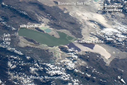 |
| Great Salt Lake oblique view On orbit over the Rocky Mountains, an astronaut aboard the International Space Station took this oblique view of Great Salt Lake (image center) and the white Bonneville Flats beyond (image top right). The lake is unique as seen from orbit because its two halves are different colors--and because the railroad causeway that divides it is a straight line aligned exactly east-west. Small rectangular patterns on both sides of the lake are evaporation ponds from which various salts are collected in commercial operations. Cities are hard to detect in daylight views from space, and Salt Lake City (image left) is almost invisible compared to the night view. The causeway on which the railroad lies bisects the original circulation of this shallow desert lake (only two small culverts under the causeway join the two halves), so that the water in each half now has different salt concentrations and different temperatures. The result appears as the color difference, because the north basin is saltier and its salt-loving algae color the water shades of red--in this view a dark red-brown (image center). The south basin typically has algae that color the water green (image left). From their vantage point astronauts can see Great Salt Lake as the remnant of a much larger lake that used to cover the entire Bonneville Flats, and other valleys in most of the state of Utah. Part of the Bonneville Flats appear at the top of the image. Water would have covered most of the view shown here, except for the Wasatch Mountains range (image lower left) and other isolated peaks that would have appeared as islands. Ancient Lake Bonneville, as it has been named, was nearly as large as Lake Michigan and existed from 32,000 to 14,000 years ago--"yesterday" in geological terms, during the last ice age when lower evaporation and meltwater from numerous glaciers allowed the lake to form. The white, salt-encrusted floor of the ancient lake has been used by racing enthusiasts for decades--the Bonneville Speedway appears image top right. This is the location where many land speed records have been set, and where annual races for all kinds of vehicles take place. |
| Images: | All Available Images Low-Resolution 304k |
|
| Mission: | ISS043 |
|
| Roll - Frame: | E - 123891 |
|
| Geographical Name: | USA-UTAH |
|
| Features: | GREAT SALT LAKE, BONNEVILLE FLATS |
|
| Center Lat x Lon: | 41.2N x 112.6W |
|
| Film Exposure: | N=Normal exposure, U=Under exposed, O=Over exposed, F=out of Focus |
|
| Percentage of Cloud Cover-CLDP: | 10 |
|
| Camera:: | N6 |
|
| Camera Tilt: | HO | LO=Low Oblique, HO=High Oblique, NV=Near Vertical |
| Camera Focal Length: | 170 |
|
| Nadir to Photo Center Direction: | SW | The direction from the nadir to the center point, N=North, S=South, E=East, W=West |
| Stereo?: | Y=Yes there is an adjacent picture of the same area, N=No there isn't |
|
| Orbit Number: | |
|
| Date: | 20150418 | YYYYMMDD |
| Time: | 220505 | GMT HHMMSS |
| Nadir Lat: | 44.3N |
Latitude of suborbital point of spacecraft |
| Nadir Lon: | 107.7W |
Longitude of suborbital point of spacecraft |
| Sun Azimuth: | 242 | Clockwise angle in degrees from north to the sun measured at the nadir point |
| Space Craft Altitude: | 215 | nautical miles |
| Sun Elevation: | 40 | Angle in degrees between the horizon and the sun, measured at the nadir point |
| Land Views: | BASIN, DESERT, RANGE |
|
| Water Views: | ICE, LAKE |
|
| Atmosphere Views: | |
|
| Man Made Views: | |
|
| City Views: | SALT LAKE CITY |
|
Photo is not associated with any sequences | ||
| NASA Home Page |
JSC Home Page |
JSC Digital Image Collection |
Earth Science & Remote Sensing |
|
This service is provided by the International Space Station program and the JSC Earth Science & Remote Sensing Unit, ARES Division, Exploration Integration Science Directorate.

|