
Geographic Region: EGYPT
Feature: ASWAN HIGH DAM, L. NASSER, AIRPORT
|
Geographic Region: EGYPT Feature: ASWAN HIGH DAM, L. NASSER, AIRPORT |
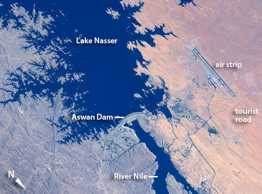 |
| Aswan High Dam, southern Egypt Astronauts aboard the International Space Station used a high magnification lens to capture the detail of the Aswan High Dam region of the River Nile in southern Egypt, a vast engineering project built between 1960 and 1970 (the Aswan Low Dam, outside the image lower right, was completed in 1902). The highly indented shoreline of 550 km-long (340 mi) Lake Nasser is a familiar sight to space-farers. Aswan International Airport lies due west near the settlement that hosts Aswan University. Completed in 1970, the Aswan High Dam is one of the largest earthen embankment dams in the world--12,565 feet (3830 m) long and nearly 3281 feet (1000 m) wide--and holds back 132 cubic km (31.7 cubic mi) of water in Lake Nasser. Hydropower generated at the dam wall provides 2.1 gigawatts, fully half of Egypt's needs when the dam was first completed (about 15% by 1998, with population growth), giving numerous villages access to electricity for the first time. The dam has virtually eliminated the danger of floods downstream in the Nile valley. Building the new reservoir necessitated the relocation not only of nearly 100,000 residents, but also of four famous archaeological sites that were reconstructed in sites above the lake level. A "tourist road" that passes near the airstrip (image right) leads to the massive rock temple of Abu Simbel (outside the image), built by Pharaoh Ramses II in the 13th century BCE. The temple was reassembled above the shoreline of Lake Nasser. |
| Images: | All Available Images Low-Resolution 122k |
|
| Mission: | ISS043 |
|
| Roll - Frame: | E - 101953 |
|
| Geographical Name: | EGYPT |
|
| Features: | ASWAN HIGH DAM, L. NASSER, AIRPORT |
|
| Center Lat x Lon: | 24.0N x 32.9E |
|
| Film Exposure: | N=Normal exposure, U=Under exposed, O=Over exposed, F=out of Focus |
|
| Percentage of Cloud Cover-CLDP: | 10 |
|
| Camera:: | N6 |
|
| Camera Tilt: | 32 | LO=Low Oblique, HO=High Oblique, NV=Near Vertical |
| Camera Focal Length: | 800 |
|
| Nadir to Photo Center Direction: | NE | The direction from the nadir to the center point, N=North, S=South, E=East, W=West |
| Stereo?: | Y=Yes there is an adjacent picture of the same area, N=No there isn't |
|
| Orbit Number: | |
|
| Date: | 20150412 | YYYYMMDD |
| Time: | 131857 | GMT HHMMSS |
| Nadir Lat: | 22.7N |
Latitude of suborbital point of spacecraft |
| Nadir Lon: | 31.0E |
Longitude of suborbital point of spacecraft |
| Sun Azimuth: | 262 | Clockwise angle in degrees from north to the sun measured at the nadir point |
| Space Craft Altitude: | 217 | nautical miles |
| Sun Elevation: | 40 | Angle in degrees between the horizon and the sun, measured at the nadir point |
| Land Views: | |
|
| Water Views: | LAKE, RESERVOIR, RIVER |
|
| Atmosphere Views: | |
|
| Man Made Views: | AIRPORT, DAM |
|
| City Views: | |
|
Photo is not associated with any sequences | ||
| NASA Home Page |
JSC Home Page |
JSC Digital Image Collection |
Earth Science & Remote Sensing |
|
This service is provided by the International Space Station program and the JSC Earth Science & Remote Sensing Unit, ARES Division, Exploration Integration Science Directorate.

|