Geographic Region: KAZAKHSTAN
Feature: L. ISSYK KUL, TIEN SHAN MTS., L. KAPCHAGAY
|
Geographic Region: KAZAKHSTAN Feature: L. ISSYK KUL, TIEN SHAN MTS., L. KAPCHAGAY |
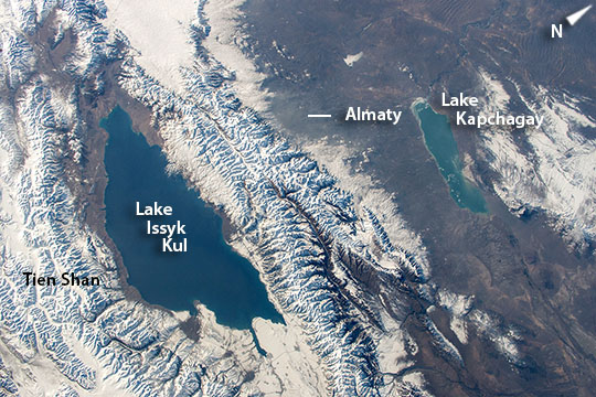 |
| Lake Issyk Kul, Kyrgyzstan, Central Asia This image was taken as astronauts aboard the International Space Station flew over one of the great mountain ranges of central Asia, the Tien Shan. Lake Issyk Kul (image lower left--182 km long) is among the largest lakes in the world; second largest mountain lake behind Lake Titicaca in South America. The lighter blue tone of the Kapchagay reservoir (image top right) reveals that it is much shallower than the dark blue Issyk Kul. Between the lakes, Almaty, capital city of Kazakhstan, is barely visible on the lower flanks of the mountains. Compared with the atmospheric clarity over the region, a dull gray smog blanket marks the city on this winter day. Lake Issyk Kul is a Ramsar Wetland site of globally significant biodiversity and forms part of the Issyk-Kul Biosphere Reserve. It has wider historical interest as a way station on one branch of the Silk Road, the ancient overland trade route between Europe and the Far East. Significant ruins dot the shores. Some historians have argued that this part of central Asia was the point of origin for the Black Death that then moved along the Silk Road to Europe and Asia during the early and mid-14th century. |
| Images: | All Available Images Low-Resolution 134k |
|
| Mission: | ISS042 |
|
| Roll - Frame: | E - 295032 |
|
| Geographical Name: | KAZAKHSTAN |
|
| Features: | L. ISSYK KUL, TIEN SHAN MTS., L. KAPCHAGAY |
|
| Center Lat x Lon: | 43.5N x 77.5E |
|
| Film Exposure: | N=Normal exposure, U=Under exposed, O=Over exposed, F=out of Focus |
|
| Percentage of Cloud Cover-CLDP: | 10 |
|
| Camera:: | N6 |
|
| Camera Tilt: | 19 | LO=Low Oblique, HO=High Oblique, NV=Near Vertical |
| Camera Focal Length: | 50 |
|
| Nadir to Photo Center Direction: | W | The direction from the nadir to the center point, N=North, S=South, E=East, W=West |
| Stereo?: | Y=Yes there is an adjacent picture of the same area, N=No there isn't |
|
| Orbit Number: | |
|
| Date: | 20150228 | YYYYMMDD |
| Time: | 105349 | GMT HHMMSS |
| Nadir Lat: | 43.0N |
Latitude of suborbital point of spacecraft |
| Nadir Lon: | 78.6E |
Longitude of suborbital point of spacecraft |
| Sun Azimuth: | 242 | Clockwise angle in degrees from north to the sun measured at the nadir point |
| Space Craft Altitude: | 213 | nautical miles |
| Sun Elevation: | 16 | Angle in degrees between the horizon and the sun, measured at the nadir point |
| Land Views: | MOUNTAIN |
|
| Water Views: | LAKE, RESERVOIR |
|
| Atmosphere Views: | SMOG |
|
| Man Made Views: | |
|
| City Views: | ALMATY |
|
Photo is not associated with any sequences | ||
| NASA Home Page |
JSC Home Page |
JSC Digital Image Collection |
Earth Science & Remote Sensing |
|
This service is provided by the International Space Station program and the JSC Earth Science & Remote Sensing Unit, ARES Division, Exploration Integration Science Directorate.

|