
Geographic Region: USA-WASHINGTON
Feature: PAN-COAST,CASCADE RA.,COLUMBIA R.,ROCKIES
|
Geographic Region: USA-WASHINGTON Feature: PAN-COAST,CASCADE RA.,COLUMBIA R.,ROCKIES |
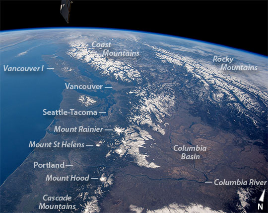 |
| This panoramic photograph was taken by an astronaut looking north from the International Space Station. The snow-covered Cascade Range of the U.S. northwest in the foreground gives way to the Rocky Mountains and Coast Mountains in Canada, with Vancouver Island just offshore. Several active volcanoes--Mount St. Helens, Mount Rainier and Mount Hood--dot the Cascades. One of the space station's solar arrays points into the view on the upper left. Short-lens panoramic views often reveal environmental patterns. The cloud bands of an approaching winter storm (upper left) signal a bout of approaching rain to what is one of the wettest parts of North America. Greener, forested landscapes are evidence of the wet climate experienced by people who live near the coast and on the seaward slopes of the mountains. By contrast, the tan colors of the dry Columbia Basin (lower right) show the rain shadow effect of the Cascades in preventing rain-bearing air masses from reaching the basin. In the foreground, the Columbia River drains the basin, cuts directly through the Cascades at Columbia River Gorge, and then flows into the Pacific Ocean. Cities typically appear as dull gray zones, but astronauts learn to detect these sometimes difficult targets. In this image, Portland, the Seattle-Tacoma metropolis, and Vancouver are all visible. Mount Rainier lies immediately southeast of Seattle about 65 kilometers (40 miles) away. |
| Images: | All Available Images Low-Resolution 101k |
|
| Mission: | ISS042 |
|
| Roll - Frame: | E - 294596 |
|
| Geographical Name: | USA-WASHINGTON |
|
| Features: | PAN-COAST,CASCADE RA.,COLUMBIA R.,ROCKIES |
|
| Center Lat x Lon: | 47.0N x 122.5W |
|
| Film Exposure: | N=Normal exposure, U=Under exposed, O=Over exposed, F=out of Focus |
|
| Percentage of Cloud Cover-CLDP: | 10 |
|
| Camera:: | N6 |
|
| Camera Tilt: | 51 | LO=Low Oblique, HO=High Oblique, NV=Near Vertical |
| Camera Focal Length: | 22 |
|
| Nadir to Photo Center Direction: | N | The direction from the nadir to the center point, N=North, S=South, E=East, W=West |
| Stereo?: | Y=Yes there is an adjacent picture of the same area, N=No there isn't |
|
| Orbit Number: | |
|
| Date: | 20150228 | YYYYMMDD |
| Time: | 182114 | GMT HHMMSS |
| Nadir Lat: | 43.0N |
Latitude of suborbital point of spacecraft |
| Nadir Lon: | 120.8W |
Longitude of suborbital point of spacecraft |
| Sun Azimuth: | 146 | Clockwise angle in degrees from north to the sun measured at the nadir point |
| Space Craft Altitude: | 211 | nautical miles |
| Sun Elevation: | 33 | Angle in degrees between the horizon and the sun, measured at the nadir point |
| Land Views: | BASIN, COAST, ISLAND, RANGE |
|
| Water Views: | OCEAN, RIVER |
|
| Atmosphere Views: | |
|
| Man Made Views: | |
|
| City Views: | COLUMBIA, PORTLAND, SEATTLE, TACOMA, VANCOUVER |
|
Photo is not associated with any sequences | ||
| NASA Home Page |
JSC Home Page |
JSC Digital Image Collection |
Earth Science & Remote Sensing |
|
This service is provided by the International Space Station program and the JSC Earth Science & Remote Sensing Unit, ARES Division, Exploration Integration Science Directorate.

|