
Geographic Region: SOMALIA
Feature: DJIBOUTI, RED SEA, G. OF ADEN
|
Geographic Region: SOMALIA Feature: DJIBOUTI, RED SEA, G. OF ADEN |
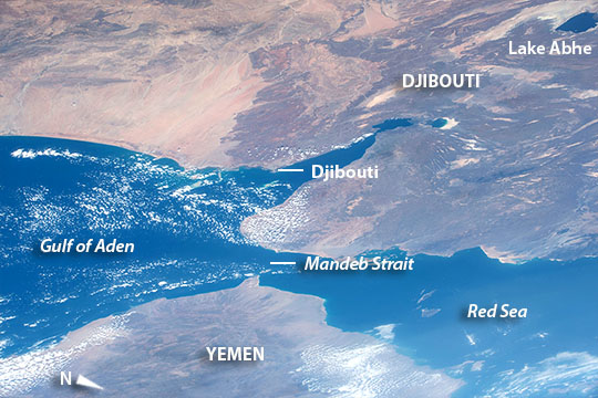 |
| Djibouti and the southern Red Sea Astronauts flying in the International Space Station took this image of the south end of the Red Sea (image lower right) and the Gulf of Aden (image left). Here the coastlines of Africa (upper part of the image) and Arabia (lower part of the image) are less than 30 km apart at the narrow point. Most of the small country of Djibouti, mainly underlain by dark volcanic rocks, is shown in this view--its long axis stretches from the Red Sea coast 220 km to Lake Abhe (image top right). Yemen lies across the Mandeb Strait (lower part of the image). Djibouti is strategically positioned on one of the world's busiest shipping lanes, controlling access to the Red Sea (and the Mediterranean beyond) and the Indian Ocean. For this reason it was occupied by France during the colonial era, while the opposite coast of Yemen was occupied by the British. Today Djibouti's port, located in the protected Tadjoura Gulf, acts as a key refueling point and import-export hub for cities inland in Ethiopia. Djibouti also hosts various foreign military bases. |
| Images: | All Available Images Low-Resolution 106k |
|
| Mission: | ISS042 |
|
| Roll - Frame: | E - 280970 |
|
| Geographical Name: | SOMALIA |
|
| Features: | DJIBOUTI, RED SEA, G. OF ADEN |
|
| Center Lat x Lon: | 11.4N x 43.4E |
|
| Film Exposure: | N=Normal exposure, U=Under exposed, O=Over exposed, F=out of Focus |
|
| Percentage of Cloud Cover-CLDP: | 10 |
|
| Camera:: | N6 |
|
| Camera Tilt: | HO | LO=Low Oblique, HO=High Oblique, NV=Near Vertical |
| Camera Focal Length: | 116 |
|
| Nadir to Photo Center Direction: | N | The direction from the nadir to the center point, N=North, S=South, E=East, W=West |
| Stereo?: | Y=Yes there is an adjacent picture of the same area, N=No there isn't |
|
| Orbit Number: | |
|
| Date: | 20150217 | YYYYMMDD |
| Time: | 090728 | GMT HHMMSS |
| Nadir Lat: | 4.4N |
Latitude of suborbital point of spacecraft |
| Nadir Lon: | 41.9E |
Longitude of suborbital point of spacecraft |
| Sun Azimuth: | 164 | Clockwise angle in degrees from north to the sun measured at the nadir point |
| Space Craft Altitude: | 215 | nautical miles |
| Sun Elevation: | 73 | Angle in degrees between the horizon and the sun, measured at the nadir point |
| Land Views: | COAST |
|
| Water Views: | GULF, LAKE, SEA, STRAIT |
|
| Atmosphere Views: | |
|
| Man Made Views: | PORT |
|
| City Views: | DJIBOUTI |
|
Photo is not associated with any sequences | ||
| NASA Home Page |
JSC Home Page |
JSC Digital Image Collection |
Earth Science & Remote Sensing |
|
This service is provided by the International Space Station program and the JSC Earth Science & Remote Sensing Unit, ARES Division, Exploration Integration Science Directorate.

|