Geographic Region: NEW ZEALAND-SI
Feature: PAN-SOUTH I., COOK STR., GLINT
|
Geographic Region: NEW ZEALAND-SI Feature: PAN-SOUTH I., COOK STR., GLINT |
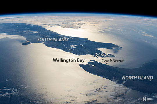 |
| New Zealand in sunglint In this panoramic image taken by astronauts aboard the International Space Station (ISS), the sun's glint point highlights the detail of Cook Strait between New Zealand's North and South Islands. Crews looking west towards a setting sun were able to see this high-contrast detail even though the center of the glint point lay fully 1000 km away from the ISS. Sunglint shows Wellington Bay (image center) -- where the capital city is located -- opening onto Cook Strait. Banks Peninsula, near the city of Christchurch, is the prominent cape (image left) whose characteristic shape is well known to ISS crews. Approaching cloud can be seen image top left. New Zealand is seldom photographed from orbit because it is one of the cloudier parts of planet, and because scheduled crew sleep periods often occur when the ISS passes over this part of the planet. |
| Images: | All Available Images Low-Resolution 71k |
|
| Mission: | ISS042 |
|
| Roll - Frame: | E - 178671 |
|
| Geographical Name: | NEW ZEALAND-SI |
|
| Features: | PAN-SOUTH I., COOK STR., GLINT |
|
| Center Lat x Lon: | 41.5S x 174.5E |
|
| Film Exposure: | N=Normal exposure, U=Under exposed, O=Over exposed, F=out of Focus |
|
| Percentage of Cloud Cover-CLDP: | 10 |
|
| Camera:: | N6 |
|
| Camera Tilt: | HO | LO=Low Oblique, HO=High Oblique, NV=Near Vertical |
| Camera Focal Length: | 70 |
|
| Nadir to Photo Center Direction: | W | The direction from the nadir to the center point, N=North, S=South, E=East, W=West |
| Stereo?: | Y=Yes there is an adjacent picture of the same area, N=No there isn't |
|
| Orbit Number: | |
|
| Date: | 20150124 | YYYYMMDD |
| Time: | 061253 | GMT HHMMSS |
| Nadir Lat: | 40.4S |
Latitude of suborbital point of spacecraft |
| Nadir Lon: | 175.8W |
Longitude of suborbital point of spacecraft |
| Sun Azimuth: | 252 | Clockwise angle in degrees from north to the sun measured at the nadir point |
| Space Craft Altitude: | 219 | nautical miles |
| Sun Elevation: | 9 | Angle in degrees between the horizon and the sun, measured at the nadir point |
| Land Views: | CAPE, PENINSULA |
|
| Water Views: | BAY, STRAIT, SUNGLINT |
|
| Atmosphere Views: | |
|
| Man Made Views: | |
|
| City Views: | CHRISTCHURCH, WELLINGTON |
|
Photo is not associated with any sequences | ||
| NASA Home Page |
JSC Home Page |
JSC Digital Image Collection |
Earth Science & Remote Sensing |
|
This service is provided by the International Space Station program and the JSC Earth Science & Remote Sensing Unit, ARES Division, Exploration Integration Science Directorate.

|