Geographic Region: LIBYA
Feature: MARZUQ SAND SEA, TIBESTI MTS.
|
Geographic Region: LIBYA Feature: MARZUQ SAND SEA, TIBESTI MTS. |
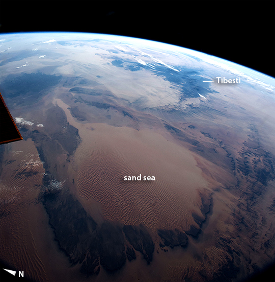 |
| Marzuq Sand Sea, Libya This picture of the central Sahara Desert was taken from the International Space Station shortly after sunrise. Tan colors of the vast, circular Marzuq Sand Sea in the foreground (300 km across, or 190 miles) contrast with the black lavas of the Tibesti Mountains near the horizon. The Sand Sea is one of the most recognizable features for orbiting astronauts, partly because they see it often under the cloudless Saharan skies. Taken with a 17 mm lens, this view replicates closely what the human eye sees--unlike the detailed images commonly taken by Space Station crews for scientists. This lens gives a strong three dimensional sense--because the Earth curves away visibly toward the horizon, and the few clouds cast shadows toward the camera. The lens even captures the effect of different sun elevation in one view. The eastern Sahara on the horizon is in full daylight but the Sand Sea in the foreground is darker where sun is just rising. |
| Images: | All Available Images Low-Resolution 267k |
|
| Mission: | ISS042 |
|
| Roll - Frame: | E - 16183 |
|
| Geographical Name: | LIBYA |
|
| Features: | MARZUQ SAND SEA, TIBESTI MTS. |
|
| Center Lat x Lon: | 24.5N x 14.5E |
|
| Film Exposure: | N=Normal exposure, U=Under exposed, O=Over exposed, F=out of Focus |
|
| Percentage of Cloud Cover-CLDP: | 10 |
|
| Camera:: | N6 |
|
| Camera Tilt: | 47 | LO=Low Oblique, HO=High Oblique, NV=Near Vertical |
| Camera Focal Length: | 17 |
|
| Nadir to Photo Center Direction: | E | The direction from the nadir to the center point, N=North, S=South, E=East, W=West |
| Stereo?: | Y=Yes there is an adjacent picture of the same area, N=No there isn't |
|
| Orbit Number: | |
|
| Date: | 20141126 | YYYYMMDD |
| Time: | 063147 | GMT HHMMSS |
| Nadir Lat: | 25.7N |
Latitude of suborbital point of spacecraft |
| Nadir Lon: | 10.7E |
Longitude of suborbital point of spacecraft |
| Sun Azimuth: | 119 | Clockwise angle in degrees from north to the sun measured at the nadir point |
| Space Craft Altitude: | 220 | nautical miles |
| Sun Elevation: | 9 | Angle in degrees between the horizon and the sun, measured at the nadir point |
| Land Views: | DESERT |
|
| Water Views: | |
|
| Atmosphere Views: | |
|
| Man Made Views: | |
|
| City Views: | |
|
Photo is not associated with any sequences | ||
| NASA Home Page |
JSC Home Page |
JSC Digital Image Collection |
Earth Science & Remote Sensing |
|
This service is provided by the International Space Station program and the JSC Earth Science & Remote Sensing Unit, ARES Division, Exploration Integration Science Directorate.

|