Geographic Region: INDIA
Feature: SOUTHERN INDIA AT NIGHT, KOCHI, GHATS
|
Geographic Region: INDIA Feature: SOUTHERN INDIA AT NIGHT, KOCHI, GHATS |
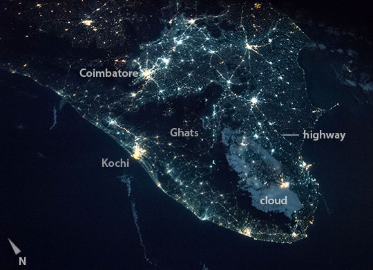 |
| Night and day images of southern India Two images taken by astronauts, one in daylight and one at night, show the peninsula of southern India. Astronauts pass from the day side of the planet to the night side sixteen times every 24 hours and therefore quickly adapt to the very different visual conditions of night and day. The night image, taken recently from the International Space Station (ISS), shows with clarity and surprising detail the human geography of cities of different sizes, such as Kochi and Coimbatore, and the highways that connect cities. The almost unpopulated hilly escarpment zone, known as the southern Ghats, is a dark zone parallel to the coast. A patch of cloud is illuminated by a near-full moon. The daylight panorama taken by crews flying aboard the Gemini-11 spacecraft shows coastlines and land surface color, but no details of human geography. This classic view was taken on an early space flight, almost 50 years ago, at a similar altitude to that of the ISS. Patterns of bright white cloud cover much of the land surfaces of India and Sri Lanka (image right). |
| Images: | All Available Images Low-Resolution 89k |
|
| Mission: | ISS042 |
|
| Roll - Frame: | E - 135100 |
|
| Geographical Name: | INDIA |
|
| Features: | SOUTHERN INDIA AT NIGHT, KOCHI, GHATS |
|
| Center Lat x Lon: | 11.5N x 77.0E |
|
| Film Exposure: | N=Normal exposure, U=Under exposed, O=Over exposed, F=out of Focus |
|
| Percentage of Cloud Cover-CLDP: | 10 |
|
| Camera:: | N6 |
|
| Camera Tilt: | 44 | LO=Low Oblique, HO=High Oblique, NV=Near Vertical |
| Camera Focal Length: | 28 |
|
| Nadir to Photo Center Direction: | N | The direction from the nadir to the center point, N=North, S=South, E=East, W=West |
| Stereo?: | Y=Yes there is an adjacent picture of the same area, N=No there isn't |
|
| Orbit Number: | |
|
| Date: | 20150112 | YYYYMMDD |
| Time: | 211305 | GMT HHMMSS |
| Nadir Lat: | 8.3N |
Latitude of suborbital point of spacecraft |
| Nadir Lon: | 75.5E |
Longitude of suborbital point of spacecraft |
| Sun Azimuth: | 117 | Clockwise angle in degrees from north to the sun measured at the nadir point |
| Space Craft Altitude: | 221 | nautical miles |
| Sun Elevation: | -57 | Angle in degrees between the horizon and the sun, measured at the nadir point |
| Land Views: | COAST, ESCARPMENT, PENINSULA |
|
| Water Views: | |
|
| Atmosphere Views: | |
|
| Man Made Views: | |
|
| City Views: | |
|
Photo is not associated with any sequences | ||
| NASA Home Page |
JSC Home Page |
JSC Digital Image Collection |
Earth Science & Remote Sensing |
|
This service is provided by the International Space Station program and the JSC Earth Science & Remote Sensing Unit, ARES Division, Exploration Integration Science Directorate.

|