
Geographic Region: ITALY
Feature: G. OF TARANTO, SEDIMENT P;LUMES
|
Geographic Region: ITALY Feature: G. OF TARANTO, SEDIMENT P;LUMES |
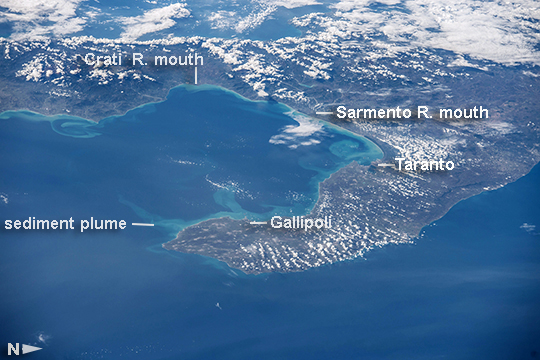 |
| Gulf of Taranto, Italy Astronauts aboard the International Space Station took this image of the Gulf of Taranto at the base of the boot of Italy. The Gulf of Taranto is roughly 140 km long and 140 km wide. The well-defined light blue swirls that hug the shorelines in the coastal waters could represent sediment introduced by local rivers or beach erosion, or they may be pollutants introduced from cities along the coastline. The tight sediment curl off the city of Taranto shows a clockwise water circulation and suggests that this major plume originates from one of the largest rivers flowing into the gulf (the Sarmento, image top right). But some contribution to the plumes seems to come from urban areas because the largest plumes are associated with the main city regions of the gulf, Taranto and Gallipoli, whereas the largest river, the Crati, gives rise only to a thin plume (image upper margin). Taranto is an important commercial and military port with steel and iron factories, oil refineries, chemical works, shipyards, and food-processing plants. |
| Images: | All Available Images Low-Resolution 248k |
|
| Mission: | ISS042 |
|
| Roll - Frame: | E - 1166 |
|
| Geographical Name: | ITALY |
|
| Features: | G. OF TARANTO, SEDIMENT P;LUMES |
|
| Center Lat x Lon: | 40.0N x 16.9E |
|
| Film Exposure: | N=Normal exposure, U=Under exposed, O=Over exposed, F=out of Focus |
|
| Percentage of Cloud Cover-CLDP: | 25 |
|
| Camera:: | N6 |
|
| Camera Tilt: | HO | LO=Low Oblique, HO=High Oblique, NV=Near Vertical |
| Camera Focal Length: | 135 |
|
| Nadir to Photo Center Direction: | W | The direction from the nadir to the center point, N=North, S=South, E=East, W=West |
| Stereo?: | Y=Yes there is an adjacent picture of the same area, N=No there isn't |
|
| Orbit Number: | |
|
| Date: | 20141109 | YYYYMMDD |
| Time: | 105257 | GMT HHMMSS |
| Nadir Lat: | 40.7N |
Latitude of suborbital point of spacecraft |
| Nadir Lon: | 25.1E |
Longitude of suborbital point of spacecraft |
| Sun Azimuth: | 194 | Clockwise angle in degrees from north to the sun measured at the nadir point |
| Space Craft Altitude: | 221 | nautical miles |
| Sun Elevation: | 31 | Angle in degrees between the horizon and the sun, measured at the nadir point |
| Land Views: | EROSION |
|
| Water Views: | GULF, SEDIMENT |
|
| Atmosphere Views: | |
|
| Man Made Views: | |
|
| City Views: | GALLIPOLI |
|
Photo is not associated with any sequences | ||
| NASA Home Page |
JSC Home Page |
JSC Digital Image Collection |
Earth Science & Remote Sensing |
|
This service is provided by the International Space Station program and the JSC Earth Science & Remote Sensing Unit, ARES Division, Exploration Integration Science Directorate.

|