
Geographic Region: AUSTRALIA-SA
Feature: FIRE SCARS, DUNES, AGR.
|
Geographic Region: AUSTRALIA-SA Feature: FIRE SCARS, DUNES, AGR. |
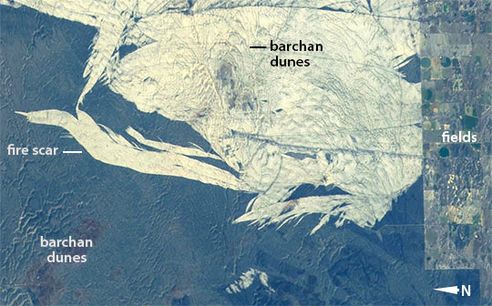 |
| Fire scar and dune shapes, southeastern Australia This astronaut image taken from the International Space Station the irregular light-toned area of a fire scar. Recent fires have burned away a vegetation cover of desert scrub to reveal a sheet of white dune sand. The fire scars taper towards the north, indicating that winds from the south (top of the image)took the fires away from start points on the agricultural fence line. At least five fire episodes can be identified by their feather-like shapes. Fire scars are often the most arresting and dominant patterns seen from aircraft and spacecraft when flying over semi-arid regions. Google Earth images of the same area (extreme southeast corner of the state of South Australia) show quite different fire-scar patterns from different years. Fires often start at or near the agricultural area--representing rural population centers. Population and fire hazard tend to go together in semi-arid areas. Close-spaced parallel lines within the white area show the curved forms of dozens of barchans dunes (horn-shaped dunes that point downwind). The dune forms show that they were formed by the dominant easterly winds (from the left side of the image)--in contrast to the southerly winds responsible for the burn scars. Subtle dune shapes can be recognized in other parts of the image--curved dune outlines underlie the dark scrub vegetation, catching the early morning sun in this view. |
| Images: | All Available Images Low-Resolution 91k |
|
| Mission: | ISS041 |
|
| Roll - Frame: | E - 55798 |
|
| Geographical Name: | AUSTRALIA-SA |
|
| Features: | FIRE SCARS, DUNES, AGR. |
|
| Center Lat x Lon: | 35.8S x 140.7E |
|
| Film Exposure: | N=Normal exposure, U=Under exposed, O=Over exposed, F=out of Focus |
|
| Percentage of Cloud Cover-CLDP: | 10 |
|
| Camera:: | N5 |
|
| Camera Tilt: | 33 | LO=Low Oblique, HO=High Oblique, NV=Near Vertical |
| Camera Focal Length: | 145 |
|
| Nadir to Photo Center Direction: | NW | The direction from the nadir to the center point, N=North, S=South, E=East, W=West |
| Stereo?: | Y=Yes there is an adjacent picture of the same area, N=No there isn't |
|
| Orbit Number: | |
|
| Date: | 20141002 | YYYYMMDD |
| Time: | 231152 | GMT HHMMSS |
| Nadir Lat: | 37.3S |
Latitude of suborbital point of spacecraft |
| Nadir Lon: | 142.6E |
Longitude of suborbital point of spacecraft |
| Sun Azimuth: | 64 | Clockwise angle in degrees from north to the sun measured at the nadir point |
| Space Craft Altitude: | 226 | nautical miles |
| Sun Elevation: | 36 | Angle in degrees between the horizon and the sun, measured at the nadir point |
| Land Views: | DESERT, DUNE |
|
| Water Views: | |
|
| Atmosphere Views: | |
|
| Man Made Views: | |
|
| City Views: | |
|
Photo is not associated with any sequences | ||
| NASA Home Page |
JSC Home Page |
JSC Digital Image Collection |
Earth Science & Remote Sensing |
|
This service is provided by the International Space Station program and the JSC Earth Science & Remote Sensing Unit, ARES Division, Exploration Integration Science Directorate.

|