
Geographic Region: IRAQ
Feature: LAND FORTIFICATIONS
|
Geographic Region: IRAQ Feature: LAND FORTIFICATIONS |
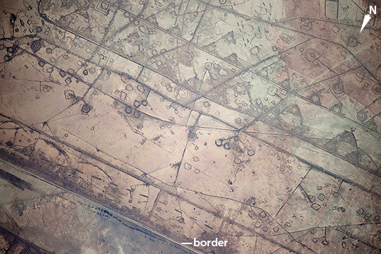 |
| Astronauts aboard the International Space Station took this photograph of land fortifications along a 20-kilometer (12-mile) stretch of the Iraq-Iran border, near the coast of the Persian Gulf. Systems of large curved earthworks, circular gun emplacements, and straight connecting roads run parallel to the international border. First thought by the ISS team to be oil-pad installations, the strategic location of these formations along the international boundary made it easier to see these as patterns of military fortifications. This region of oil refining and exporting was the center of numerous military actions during the war in the 1980s, especially during the defense of the southern city of Basra. The similarity to oil-pad patterns is apparent in May 2006 astronaut photos of West Texas that you can see here and here. |
| Images: | All Available Images Low-Resolution 302k |
|
| Mission: | ISS041 |
|
| Roll - Frame: | E - 111072 |
|
| Geographical Name: | IRAQ |
|
| Features: | LAND FORTIFICATIONS |
|
| Center Lat x Lon: | 30.9N x 47.9E |
|
| Film Exposure: | N=Normal exposure, U=Under exposed, O=Over exposed, F=out of Focus |
|
| Percentage of Cloud Cover-CLDP: | 10 |
|
| Camera:: | N6 |
|
| Camera Tilt: | 22 | LO=Low Oblique, HO=High Oblique, NV=Near Vertical |
| Camera Focal Length: | 800 |
|
| Nadir to Photo Center Direction: | S | The direction from the nadir to the center point, N=North, S=South, E=East, W=West |
| Stereo?: | Y=Yes there is an adjacent picture of the same area, N=No there isn't |
|
| Orbit Number: | |
|
| Date: | 20141107 | YYYYMMDD |
| Time: | 110010 | GMT HHMMSS |
| Nadir Lat: | 32.4N |
Latitude of suborbital point of spacecraft |
| Nadir Lon: | 47.8E |
Longitude of suborbital point of spacecraft |
| Sun Azimuth: | 222 | Clockwise angle in degrees from north to the sun measured at the nadir point |
| Space Craft Altitude: | 222 | nautical miles |
| Sun Elevation: | 30 | Angle in degrees between the horizon and the sun, measured at the nadir point |
| Land Views: | |
|
| Water Views: | |
|
| Atmosphere Views: | |
|
| Man Made Views: | |
|
| City Views: | |
|
Photo is not associated with any sequences | ||
| NASA Home Page |
JSC Home Page |
JSC Digital Image Collection |
Earth Science & Remote Sensing |
|
This service is provided by the International Space Station program and the JSC Earth Science & Remote Sensing Unit, ARES Division, Exploration Integration Science Directorate.

|