 Photo #: ISS041-E-105277 Date: Oct. 2014
Geographic Region: AUSTRALIA-NT
Feature: THUNDERCLOUD ANVIL SILHOUETTE, LIMB
|
Photo #: ISS041-E-105277 Date: Oct. 2014 Geographic Region: AUSTRALIA-NT Feature: THUNDERCLOUD ANVIL SILHOUETTE, LIMB |
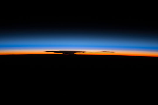 |
| Thunderhead with anvil, Australia Astronauts aboard the International Space Station (ISS) took this image of a large thundercloud at sunset from a point over Papua New Guinea. The side-on view shows that the cloud was in the vicinity of the horizon more than 1500 km west of the spacecraft, suggesting that the cloud lay over northern Australia or the Gulf of Carpentaria. With enough convective energy, clouds in the lowest layer of the atmosphere, the troposphere, can rise until they bump up against the stable overlying layer, at which point they spread sideways, making a thin upper zone shaped like an anvil, such as the one seen here. Knowing the camera lens focal length and the cloud location near the horizon, this expansive anvil measures approximately 200 km. The spectacular detail seen in side-on views, backlit by the bright atmosphere, shows no rain falling from most of the cloud. The warm colors of the troposphere, compared with the blues above, are partly a measure of dust and other particulates that reflect red and yellow wavelengths. Astronauts often comment on the thinness of the Earth's life-supporting envelope, and how it suggests the fragility of our planetary ecosystem. They also note that the number of atmospheric layers they detect with their eyes is much greater than their photographs show. |
| Images: | All Available Images Low-Resolution 38k |
|
| Mission: | ISS041 |
|
| Roll - Frame: | E - 105277 |
|
| Geographical Name: | AUSTRALIA-NT |
|
| Features: | THUNDERCLOUD ANVIL SILHOUETTE, LIMB |
|
| Center Lat x Lon: | N x E |
|
| Film Exposure: | N=Normal exposure, U=Under exposed, O=Over exposed, F=out of Focus |
|
| Percentage of Cloud Cover-CLDP: | 10 |
|
| Camera:: | N6 |
|
| Camera Tilt: | HO | LO=Low Oblique, HO=High Oblique, NV=Near Vertical |
| Camera Focal Length: | 200 |
|
| Nadir to Photo Center Direction: | The direction from the nadir to the center point, N=North, S=South, E=East, W=West |
|
| Stereo?: | Y=Yes there is an adjacent picture of the same area, N=No there isn't |
|
| Orbit Number: | |
|
| Date: | 20141030 | YYYYMMDD |
| Time: | 095513 | GMT HHMMSS |
| Nadir Lat: | 10.3S |
Latitude of suborbital point of spacecraft |
| Nadir Lon: | 150.1E |
Longitude of suborbital point of spacecraft |
| Sun Azimuth: | 248 | Clockwise angle in degrees from north to the sun measured at the nadir point |
| Space Craft Altitude: | 225 | nautical miles |
| Sun Elevation: | -28 | Angle in degrees between the horizon and the sun, measured at the nadir point |
| Land Views: | |
|
| Water Views: | |
|
| Atmosphere Views: | |
|
| Man Made Views: | |
|
| City Views: | |
|
Photo is not associated with any sequences | ||
| NASA Home Page |
JSC Home Page |
JSC Digital Image Collection |
Earth Science & Remote Sensing |
|
This service is provided by the International Space Station program and the JSC Earth Science & Remote Sensing Unit, ARES Division, Exploration Integration Science Directorate.

|