
Geographic Region: USA-ILLINOIS
Feature: CHICAGO, LOOP, CHICAGO R., L. MICHIGAN
|
Geographic Region: USA-ILLINOIS Feature: CHICAGO, LOOP, CHICAGO R., L. MICHIGAN |
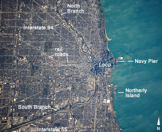 |
| Chicago, Illinois This image of Chicago and 16 miles (26 km) of the Lake Michigan shoreline was taken from the International Space Station. It shows how natural features control the growth of the city. Chicago's center--known as the Loop--lies at the mouth of the Chicago River, reflecting a time when this was the earliest settlement at a point where lake and river traffic converged. Navy Pier was built in 1916 at this transportation node primarily as a cargo facility for lake freighters. The city center still occupies the same location nearly two hundred years later. Modern highways (I-94 and I-55) prominently are aligned toward the city center, following older transportation routes that ran along the banks of the North and South Branches of the Chicago River-that are still used by barge traffic. Railroads also converge on the city center. Residential and business land uses are competing with the transport functions. For example, Meigs Field was the small downtown airport located on Northerly Island that was bulldozed in 2003 to make way for a city waterfront park. The city center is distinctly darker as seen from orbit because high rise buildings in the Loop cast much more shadow than low buildings in the surrounding neighborhoods. |
| Images: | All Available Images Low-Resolution 430k |
|
| Mission: | ISS041 |
|
| Roll - Frame: | E - 103791 |
|
| Geographical Name: | USA-ILLINOIS |
|
| Features: | CHICAGO, LOOP, CHICAGO R., L. MICHIGAN |
|
| Center Lat x Lon: | 41.8N x 87.9W |
|
| Film Exposure: | N=Normal exposure, U=Under exposed, O=Over exposed, F=out of Focus |
|
| Percentage of Cloud Cover-CLDP: | 10 |
|
| Camera:: | N6 |
|
| Camera Tilt: | 29 | LO=Low Oblique, HO=High Oblique, NV=Near Vertical |
| Camera Focal Length: | 800 |
|
| Nadir to Photo Center Direction: | S | The direction from the nadir to the center point, N=North, S=South, E=East, W=West |
| Stereo?: | Y=Yes there is an adjacent picture of the same area, N=No there isn't |
|
| Orbit Number: | |
|
| Date: | 20141028 | YYYYMMDD |
| Time: | 170906 | GMT HHMMSS |
| Nadir Lat: | 43.8N |
Latitude of suborbital point of spacecraft |
| Nadir Lon: | 87.7W |
Longitude of suborbital point of spacecraft |
| Sun Azimuth: | 173 | Clockwise angle in degrees from north to the sun measured at the nadir point |
| Space Craft Altitude: | 220 | nautical miles |
| Sun Elevation: | 33 | Angle in degrees between the horizon and the sun, measured at the nadir point |
| Land Views: | ISLAND |
|
| Water Views: | LAKE, RIVER |
|
| Atmosphere Views: | |
|
| Man Made Views: | |
|
| City Views: | CHICAGO |
|
Photo is not associated with any sequences | ||
| NASA Home Page |
JSC Home Page |
JSC Digital Image Collection |
Earth Science & Remote Sensing |
|
This service is provided by the International Space Station program and the JSC Earth Science & Remote Sensing Unit, ARES Division, Exploration Integration Science Directorate.

|