
Geographic Region: AUSTRALIA-WA
Feature: KING SOUND, SEDIMENT, SMOKE PLUMES
|
Geographic Region: AUSTRALIA-WA Feature: KING SOUND, SEDIMENT, SMOKE PLUMES |
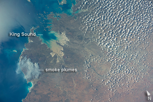 |
| King Sound, Australia Astronauts aboard the International Space Station took this image of King Sound on the northwest coast of Australia. The Fitzroy River, one of Australia's largest, empties into the Sound, a large gulf in Western Australia (approximately 120 km long). King Sound has the highest tides in Australia, in the range of 11-12 meters, the second highest in the world after the Bay of Fundy on the east coast of North America. The strong brown smudge at the head of the Sound contrasts with the clearer blue water along the rest of the coast. This is mud stirred up by the tides and also supplied by the Fitzroy River. The bright reflection point of the sun obscures the blue water of the Indian Ocean (image top left). Just to the west of the Sound, thick plumes of wildfire smoke, driven by northeast winds, obscure the coastline. A wide field of "popcorn cumulus" clouds (image right) is a common effect of daily heating of the ground surface. The Sound is named after Philip King who surveyed the coastline in 1818. In the 1880s the area experienced a short-lived gold rush. |
| Images: | All Available Images Low-Resolution 287k |
|
| Mission: | ISS040 |
|
| Roll - Frame: | E - 89959 |
|
| Geographical Name: | AUSTRALIA-WA |
|
| Features: | KING SOUND, SEDIMENT, SMOKE PLUMES |
|
| Center Lat x Lon: | 17.5S x 124.5E |
|
| Film Exposure: | N=Normal exposure, U=Under exposed, O=Over exposed, F=out of Focus |
|
| Percentage of Cloud Cover-CLDP: | 25 |
|
| Camera:: | N5 |
|
| Camera Tilt: | 02 | LO=Low Oblique, HO=High Oblique, NV=Near Vertical |
| Camera Focal Length: | 28 |
|
| Nadir to Photo Center Direction: | SE | The direction from the nadir to the center point, N=North, S=South, E=East, W=West |
| Stereo?: | Y=Yes there is an adjacent picture of the same area, N=No there isn't |
|
| Orbit Number: | |
|
| Date: | 20140808 | YYYYMMDD |
| Time: | 070353 | GMT HHMMSS |
| Nadir Lat: | 17.4S |
Latitude of suborbital point of spacecraft |
| Nadir Lon: | 124.4E |
Longitude of suborbital point of spacecraft |
| Sun Azimuth: | 302 | Clockwise angle in degrees from north to the sun measured at the nadir point |
| Space Craft Altitude: | 223 | nautical miles |
| Sun Elevation: | 31 | Angle in degrees between the horizon and the sun, measured at the nadir point |
| Land Views: | COAST |
|
| Water Views: | BAY, GULF, OCEAN, RIVER |
|
| Atmosphere Views: | SMOKE |
|
| Man Made Views: | |
|
| City Views: | |
|
Photo is not associated with any sequences | ||
| NASA Home Page |
JSC Home Page |
JSC Digital Image Collection |
Earth Science & Remote Sensing |
|
This service is provided by the International Space Station program and the JSC Earth Science & Remote Sensing Unit, ARES Division, Exploration Integration Science Directorate.

|