Geographic Region: INDONESIA-B
Feature: THUNDERHEADS, C. SELATAN, SMOKE PLUMES
|
Geographic Region: INDONESIA-B Feature: THUNDERHEADS, C. SELATAN, SMOKE PLUMES |
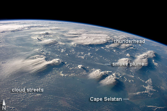 |
| Thunderheads, Borneo, Indonesia Late afternoon sun casts long shadows from high thunderhead anvils over southern Borneo. Crews aboard the International Space Station have recently concentrated on panoramic views of clouds--taken with lenses similar to the focal length of the human eye. These images reveal the kinds of views crews see -- huge areas of the planet, with a strong three-dimensional sense of what it is like to fly 350 km above the Earth. Winds usually blow in different directions at different altitudes. High-altitude winds are clearly sweeping the tops off the many tallest thunderclouds, generating long anvils of diffuse cirrus plumes that trail south. At low levels, "streets" of white dots -- fair-weather cumulus clouds -- are aligned with west-moving winds (image lower left). Small smoke plumes from forest fires onshore are also aligned west. Storm formation near the horizon -- more than 1000 km distant (image center) -- is assisted as air currents rise over the central mountains of Borneo. |
| Images: | All Available Images Low-Resolution 85k |
|
| Mission: | ISS040 |
|
| Roll - Frame: | E - 88891 |
|
| Geographical Name: | INDONESIA-B |
|
| Features: | THUNDERHEADS, C. SELATAN, SMOKE PLUMES |
|
| Center Lat x Lon: | 3S x 114.0E |
|
| Film Exposure: | N=Normal exposure, U=Under exposed, O=Over exposed, F=out of Focus |
|
| Percentage of Cloud Cover-CLDP: | 75 |
|
| Camera:: | N5 |
|
| Camera Tilt: | 55 | LO=Low Oblique, HO=High Oblique, NV=Near Vertical |
| Camera Focal Length: | 28 |
|
| Nadir to Photo Center Direction: | N | The direction from the nadir to the center point, N=North, S=South, E=East, W=West |
| Stereo?: | Y=Yes there is an adjacent picture of the same area, N=No there isn't |
|
| Orbit Number: | |
|
| Date: | 20140805 | YYYYMMDD |
| Time: | 093043 | GMT HHMMSS |
| Nadir Lat: | 8.1S |
Latitude of suborbital point of spacecraft |
| Nadir Lon: | 112.7E |
Longitude of suborbital point of spacecraft |
| Sun Azimuth: | 290 | Clockwise angle in degrees from north to the sun measured at the nadir point |
| Space Craft Altitude: | 223 | nautical miles |
| Sun Elevation: | 13 | Angle in degrees between the horizon and the sun, measured at the nadir point |
| Land Views: | |
|
| Water Views: | |
|
| Atmosphere Views: | SMOKE |
|
| Man Made Views: | |
|
| City Views: | |
|
Photo is not associated with any sequences | ||
| NASA Home Page |
JSC Home Page |
JSC Digital Image Collection |
Earth Science & Remote Sensing |
|
This service is provided by the International Space Station program and the JSC Earth Science & Remote Sensing Unit, ARES Division, Exploration Integration Science Directorate.

|