Geographic Region: BOTSWANA
Feature: PAN-OKAVANGO DELTA, GLINT, DRY LAKES
|
Geographic Region: BOTSWANA Feature: PAN-OKAVANGO DELTA, GLINT, DRY LAKES |
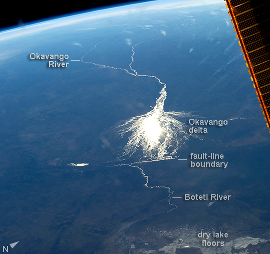 |
| Okavango Inland Delta, northern Botswana The great Okavango delta in the Kalahari Desert is illuminated in the sun's reflection point in this panorama taken from the International Space Station. Using this sun glint technique, astronauts can image fine detail of water bodies. Here the bright line of the Okavango River shows the annual summer flood advancing from the well-watered Angolan Highlands (upper image margin) to the delta. Then the flood water slowly seeps across the 150 km-long delta, supplying forests and wetlands, finally reaching the fault-bounded lower margin of the delta in the middle of winter. Most of the water of this large river is used up by the forests, or evaporates in the dry air. Only 2% of the river's water actually exits the delta. The wetland supports high biodiversity in the middle of the otherwise semiarid Kalahari Desert, and is now one of the most famous tourist sites in Africa. This view also shows the small quantity of water in the Boteti River. Okavango water only reaches the dry lake floors (image lower right) in the wettest years. Part of one of the ISS solar arrays is visible at image upper right. |
| Images: | All Available Images Low-Resolution 275k |
|
| Mission: | ISS040 |
|
| Roll - Frame: | E - 8209 |
|
| Geographical Name: | BOTSWANA |
|
| Features: | PAN-OKAVANGO DELTA, GLINT, DRY LAKES |
|
| Center Lat x Lon: | 19S x 23.0E |
|
| Film Exposure: | N=Normal exposure, U=Under exposed, O=Over exposed, F=out of Focus |
|
| Percentage of Cloud Cover-CLDP: | 10 |
|
| Camera:: | N5 |
|
| Camera Tilt: | HO | LO=Low Oblique, HO=High Oblique, NV=Near Vertical |
| Camera Focal Length: | 42 |
|
| Nadir to Photo Center Direction: | W | The direction from the nadir to the center point, N=North, S=South, E=East, W=West |
| Stereo?: | Y=Yes there is an adjacent picture of the same area, N=No there isn't |
|
| Orbit Number: | |
|
| Date: | 20140606 | YYYYMMDD |
| Time: | 135423 | GMT HHMMSS |
| Nadir Lat: | 21.6S |
Latitude of suborbital point of spacecraft |
| Nadir Lon: | 30.6E |
Longitude of suborbital point of spacecraft |
| Sun Azimuth: | 304 | Clockwise angle in degrees from north to the sun measured at the nadir point |
| Space Craft Altitude: | 226 | nautical miles |
| Sun Elevation: | 17 | Angle in degrees between the horizon and the sun, measured at the nadir point |
| Land Views: | DESERT |
|
| Water Views: | DELTA, LAKE, RIVER |
|
| Atmosphere Views: | |
|
| Man Made Views: | |
|
| City Views: | |
|
Photo is not associated with any sequences | ||
| NASA Home Page |
JSC Home Page |
JSC Digital Image Collection |
Earth Science & Remote Sensing |
|
This service is provided by the International Space Station program and the JSC Earth Science & Remote Sensing Unit, ARES Division, Exploration Integration Science Directorate.

|