Geographic Region: RUSSIAN FEDERATION
Feature: KULUNDA STEPPE, FOLDED ROCKS, OB R.
|
Geographic Region: RUSSIAN FEDERATION Feature: KULUNDA STEPPE, FOLDED ROCKS, OB R. |
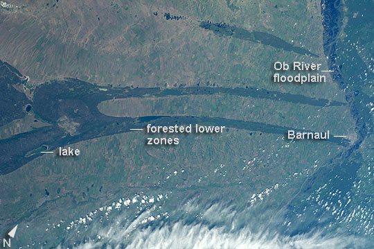 |
| Kulunda Steppe, Siberia, central Russia The crew aboard the International Space Station (ISS) called down to Houston to ask for an explanation of this strange pattern of spikes crossing the Kulunda Steppe in central Russia. The "spikes" are a prominent visual feature (image center) visible from the top of the ISS orbit (approximately 52 degrees north), the highest latitude flown over by the space craft. In fact these linear zones are gentle folds in the surface rocks of the area, lying slightly lower than the surrounding lighter-toned agricultural lands. The dark zones are forested with pines and dotted with salt-rich lakes. The image width (left to right edge) represents more than 300 km ground distance, and the forested spikes are nearly that length. The green floodplain of the famous Ob River (image right) is the westernmost of Siberia's three great rivers (the others being the Yenisei and Lena). The Ob flows north (towards the top of the image) for another 2000 km to the Arctic Ocean. The city of Barnaul (population 612,000), a major center of industry, trade and culture in Siberia, lies on the banks of the river with riverboat, air and rail links to the rest of the country. A broader, winter image of the Kulunda geology and the Ob River can be seen here. |
| Images: | All Available Images Low-Resolution 97k |
|
| Mission: | ISS040 |
|
| Roll - Frame: | E - 27042 |
|
| Geographical Name: | RUSSIAN FEDERATION |
|
| Features: | KULUNDA STEPPE, FOLDED ROCKS, OB R. |
|
| Center Lat x Lon: | 52.5N x 81.5E |
|
| Film Exposure: | N=Normal exposure, U=Under exposed, O=Over exposed, F=out of Focus |
|
| Percentage of Cloud Cover-CLDP: | 10 |
|
| Camera:: | N5 |
|
| Camera Tilt: | 36 | LO=Low Oblique, HO=High Oblique, NV=Near Vertical |
| Camera Focal Length: | 80 |
|
| Nadir to Photo Center Direction: | NE | The direction from the nadir to the center point, N=North, S=South, E=East, W=West |
| Stereo?: | Y=Yes there is an adjacent picture of the same area, N=No there isn't |
|
| Orbit Number: | |
|
| Date: | 20140630 | YYYYMMDD |
| Time: | 091101 | GMT HHMMSS |
| Nadir Lat: | 51.3N |
Latitude of suborbital point of spacecraft |
| Nadir Lon: | 79.1E |
Longitude of suborbital point of spacecraft |
| Sun Azimuth: | 238 | Clockwise angle in degrees from north to the sun measured at the nadir point |
| Space Craft Altitude: | 221 | nautical miles |
| Sun Elevation: | 51 | Angle in degrees between the horizon and the sun, measured at the nadir point |
| Land Views: | |
|
| Water Views: | RIVER |
|
| Atmosphere Views: | |
|
| Man Made Views: | |
|
| City Views: | BARNAUL |
|
Photo is not associated with any sequences | ||
| NASA Home Page |
JSC Home Page |
JSC Digital Image Collection |
Earth Science & Remote Sensing |
|
This service is provided by the International Space Station program and the JSC Earth Science & Remote Sensing Unit, ARES Division, Exploration Integration Science Directorate.

|