
Geographic Region: IRAN
Feature: LAKE URMIA, URMIA, MIANDOAB
|
Geographic Region: IRAN Feature: LAKE URMIA, URMIA, MIANDOAB |
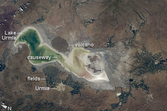 |
| Lake Urmia, Iran Green and tan shades show the extent of the water surface of Lake Urmia (also Orumiyeh, Orumieh) in westernmost Iran. The lake is highly saline and only a few tens of meters deep even at high water. The shoreline appears as a white margin of salt. Rivers that flow into the lake appear as narrow green lines (especially on the southeastern lake margin; image top right), and these form deltas where soft soils and a nearby water supply allow farming, areas marked by clusters of green agricultural fields. The lake and its wetlands have been declared a UNESCO Biosphere Reserve. The lake is one of the largest in the Middle East, measuring 130 km from the northern shoreline to the vegetated delta image right. The city of Urmia stands out as a distinct gray patch surrounded by fields at image lower left. On the opposite shore from the city an extinct volcano appears as an oval shape. A causeway and bridge connect the opposite shorelines at this point. More detailed images of the causeway can be seen here. The lake is experiencing a drastic loss of water, and now holds only approximately 5% of its known high-stage volume. The drying is vividly illustrated by the fact that the volcano used to be entirely surrounded by the lake. The cause of the drop in water levels is related to extraction of water for farming and a long-term decrease in rainfall. |
| Images: | All Available Images Low-Resolution 88k |
|
| Mission: | ISS040 |
|
| Roll - Frame: | E - 17264 |
|
| Geographical Name: | IRAN |
|
| Features: | LAKE URMIA, URMIA, MIANDOAB |
|
| Center Lat x Lon: | 37.5N x 45.5E |
|
| Film Exposure: | N=Normal exposure, U=Under exposed, O=Over exposed, F=out of Focus |
|
| Percentage of Cloud Cover-CLDP: | 10 |
|
| Camera:: | N5 |
|
| Camera Tilt: | 18 | LO=Low Oblique, HO=High Oblique, NV=Near Vertical |
| Camera Focal Length: | 80 |
|
| Nadir to Photo Center Direction: | SW | The direction from the nadir to the center point, N=North, S=South, E=East, W=West |
| Stereo?: | Y=Yes there is an adjacent picture of the same area, N=No there isn't |
|
| Orbit Number: | |
|
| Date: | 20140623 | YYYYMMDD |
| Time: | 095525 | GMT HHMMSS |
| Nadir Lat: | 38.1N |
Latitude of suborbital point of spacecraft |
| Nadir Lon: | 46.5E |
Longitude of suborbital point of spacecraft |
| Sun Azimuth: | 225 | Clockwise angle in degrees from north to the sun measured at the nadir point |
| Space Craft Altitude: | 220 | nautical miles |
| Sun Elevation: | 71 | Angle in degrees between the horizon and the sun, measured at the nadir point |
| Land Views: | VOLCANO |
|
| Water Views: | DELTA, LAKE |
|
| Atmosphere Views: | |
|
| Man Made Views: | BRIDGE |
|
| City Views: | |
|
Photo is not associated with any sequences | ||
| NASA Home Page |
JSC Home Page |
JSC Digital Image Collection |
Earth Science & Remote Sensing |
|
This service is provided by the International Space Station program and the JSC Earth Science & Remote Sensing Unit, ARES Division, Exploration Integration Science Directorate.

|