
Geographic Region: USA-WASHINGTON
Feature: SEATTLE, PUGET SOUND, GLINT, SHIP WAKES
|
Geographic Region: USA-WASHINGTON Feature: SEATTLE, PUGET SOUND, GLINT, SHIP WAKES |
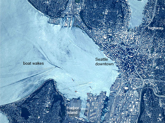 |
| Seattle and boat wakes Puget Sound is partly reflecting the sun in this detailed image taken by astronauts on the International Space Station. Patterns of boat wakes are prominent in this reflection zone. The difference between the boat wakes in this view relates to the speed of the boat and the particular patterns (of several) that happen to be captured in the specific light reflection angles at the time the image was taken. The land areas show parts of Seattle. The darkest areas with rectangular grids are suburbs richly covered with trees. The broadly gray zones of the central city are brighter where structures are lower, as in the harbor zone (Harbor Island), and darker where the shadows of high-rise buildings downtown cast black shadows. Interstate Highway 5 bisects downtown. |
| Images: | All Available Images Low-Resolution 143k |
|
| Mission: | ISS040 |
|
| Roll - Frame: | E - 124198 |
|
| Geographical Name: | USA-WASHINGTON |
|
| Features: | SEATTLE, PUGET SOUND, GLINT, SHIP WAKES |
|
| Center Lat x Lon: | 47.6N x 122.4W |
|
| Film Exposure: | N=Normal exposure, U=Under exposed, O=Over exposed, F=out of Focus |
|
| Percentage of Cloud Cover-CLDP: | 10 |
|
| Camera:: | N2 |
|
| Camera Tilt: | 35 | LO=Low Oblique, HO=High Oblique, NV=Near Vertical |
| Camera Focal Length: | 800 |
|
| Nadir to Photo Center Direction: | S | The direction from the nadir to the center point, N=North, S=South, E=East, W=West |
| Stereo?: | Y=Yes there is an adjacent picture of the same area, N=No there isn't |
|
| Orbit Number: | |
|
| Date: | 20140906 | YYYYMMDD |
| Time: | 201040 | GMT HHMMSS |
| Nadir Lat: | 50.0N |
Latitude of suborbital point of spacecraft |
| Nadir Lon: | 123.2W |
Longitude of suborbital point of spacecraft |
| Sun Azimuth: | 180 | Clockwise angle in degrees from north to the sun measured at the nadir point |
| Space Craft Altitude: | 220 | nautical miles |
| Sun Elevation: | 46 | Angle in degrees between the horizon and the sun, measured at the nadir point |
| Land Views: | ISLAND |
|
| Water Views: | |
|
| Atmosphere Views: | |
|
| Man Made Views: | HARBOR, HIGHWAY |
|
| City Views: | SEATTLE |
|
Photo is not associated with any sequences | ||
| NASA Home Page |
JSC Home Page |
JSC Digital Image Collection |
Earth Science & Remote Sensing |
|
This service is provided by the International Space Station program and the JSC Earth Science & Remote Sensing Unit, ARES Division, Exploration Integration Science Directorate.

|