Geographic Region: BRAZIL
Feature: FIRES, RAINFOREST, DEFORESTATION PATCHES
|
Geographic Region: BRAZIL Feature: FIRES, RAINFOREST, DEFORESTATION PATCHES |
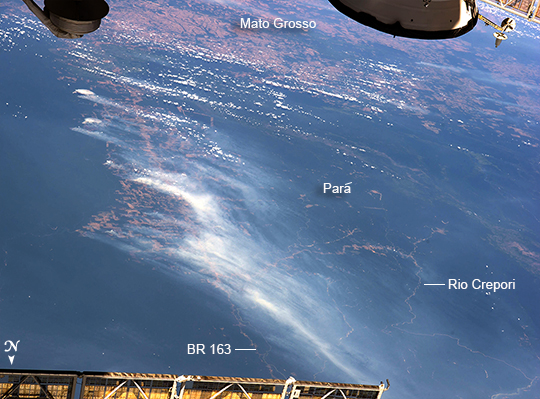 |
| Amazon forest burning season, Brazil On an unusually cloud-free day at the height of the dry season in Amazonia, several fires were burning, giving rise to a broad smoke pall easily seen from the International Space Station (ISS). Parts of the ISS appear along the margins of the image. Against the backdrop of the dark green rainforest, several fires follow the major highway BR 163 (lower center of the image to the top left). Fires are set to clear patches of forest for agriculture, a process that reveals red-brown soils. A long line of new cleared patches snakes east from BR 163 towards the remote valley of the Rio Crepori. Extensive deforested areas in Brazil's state of Mato Grosso appear as tan areas across the top of the image. Fires show the advance of deforestation into the state of Para, the area shown in most of this view. Para is now second after Mato Grosso in terms of deforestation acreage. |
| Images: | All Available Images Low-Resolution 278k |
|
| Mission: | ISS040 |
|
| Roll - Frame: | E - 103496 |
|
| Geographical Name: | BRAZIL |
|
| Features: | FIRES, RAINFOREST, DEFORESTATION PATCHES |
|
| Center Lat x Lon: | 7.5S x 56W |
|
| Film Exposure: | N=Normal exposure, U=Under exposed, O=Over exposed, F=out of Focus |
|
| Percentage of Cloud Cover-CLDP: | 10 |
|
| Camera:: | N5 |
|
| Camera Tilt: | HO | LO=Low Oblique, HO=High Oblique, NV=Near Vertical |
| Camera Focal Length: | 70 |
|
| Nadir to Photo Center Direction: | S | The direction from the nadir to the center point, N=North, S=South, E=East, W=West |
| Stereo?: | Y=Yes there is an adjacent picture of the same area, N=No there isn't |
|
| Orbit Number: | |
|
| Date: | 20140819 | YYYYMMDD |
| Time: | 152535 | GMT HHMMSS |
| Nadir Lat: | .5N |
Latitude of suborbital point of spacecraft |
| Nadir Lon: | 53.9W |
Longitude of suborbital point of spacecraft |
| Sun Azimuth: | 15 | Clockwise angle in degrees from north to the sun measured at the nadir point |
| Space Craft Altitude: | 224 | nautical miles |
| Sun Elevation: | 77 | Angle in degrees between the horizon and the sun, measured at the nadir point |
| Land Views: | FOREST, VALLEY |
|
| Water Views: | |
|
| Atmosphere Views: | SMOKE, SMOKE PALL |
|
| Man Made Views: | AGRICULTURE, DEFORESTATION, HIGHWAY |
|
| City Views: | |
|
Photo is not associated with any sequences | ||
| NASA Home Page |
JSC Home Page |
JSC Digital Image Collection |
Earth Science & Remote Sensing |
|
This service is provided by the International Space Station program and the JSC Earth Science & Remote Sensing Unit, ARES Division, Exploration Integration Science Directorate.

|