 Photo #: ISS040-E-103491 Date: Aug. 2014
Geographic Region: BRAZIL
Feature: AMAZON RIVER, FLOODPLAIN, LAKES, GLINT
|
Photo #: ISS040-E-103491 Date: Aug. 2014 Geographic Region: BRAZIL Feature: AMAZON RIVER, FLOODPLAIN, LAKES, GLINT |
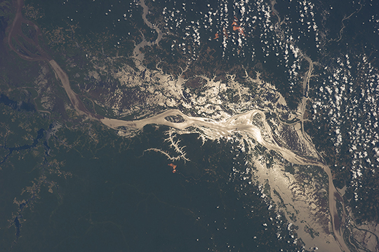 |
| Amazon River, Brazil, in sunglint Astronauts aboard the International Space Station use the sun's reflection point to reveal features that are otherwise difficult or impossible to see. Viewed from 180 miles (290 km) above the earth's surface, the world's largest river, the Amazon, crosses the image (from the top left to the lower right), snaking its way through its floodplain that is more than 20 miles (32 km) wide. Sunglint from the water surface shows the numerous lakes and side tributaries on the floodplain. The extensive lakes have a longer history to tell (one lake, lower right, is more than 12 miles, 19 km, wide). The Amazon River cut a canyon tens of meters deep in response to the fall of sea level during the geologically recent glacial stages. Sea level rose again with rapid melting of the ice sheets, and to keep pace the Amazon River bed has also risen - filling the canyon with vast quantities of sediment from the distant Andes Mountains in the process. The continued existence of the lake depressions shows that this filling process is not yet complete. Numerous lighter-toned patches of deforestation dot the left margin of the image. Small bright red patches on higher ground either side of the floodplain are open-cast mines where the red soils that underlie the rainforest are exposed (image center, image upper margin). |
| Images: | All Available Images Low-Resolution 279k |
|
| Mission: | ISS040 |
|
| Roll - Frame: | E - 103491 |
|
| Geographical Name: | BRAZIL |
|
| Features: | AMAZON RIVER, FLOODPLAIN, LAKES, GLINT |
|
| Center Lat x Lon: | 2S x 56.5W |
|
| Film Exposure: | N=Normal exposure, U=Under exposed, O=Over exposed, F=out of Focus |
|
| Percentage of Cloud Cover-CLDP: | 10 |
|
| Camera:: | N5 |
|
| Camera Tilt: | 15 | LO=Low Oblique, HO=High Oblique, NV=Near Vertical |
| Camera Focal Length: | 70 |
|
| Nadir to Photo Center Direction: | W | The direction from the nadir to the center point, N=North, S=South, E=East, W=West |
| Stereo?: | Y=Yes there is an adjacent picture of the same area, N=No there isn't |
|
| Orbit Number: | |
|
| Date: | 20140819 | YYYYMMDD |
| Time: | 152450 | GMT HHMMSS |
| Nadir Lat: | 1.8S |
Latitude of suborbital point of spacecraft |
| Nadir Lon: | 55.5W |
Longitude of suborbital point of spacecraft |
| Sun Azimuth: | 19 | Clockwise angle in degrees from north to the sun measured at the nadir point |
| Space Craft Altitude: | 224 | nautical miles |
| Sun Elevation: | 75 | Angle in degrees between the horizon and the sun, measured at the nadir point |
| Land Views: | |
|
| Water Views: | LAKE, RIVER, SUNGLINT |
|
| Atmosphere Views: | |
|
| Man Made Views: | DEFORESTATION |
|
| City Views: | |
|
Photo is not associated with any sequences | ||
| NASA Home Page |
JSC Home Page |
JSC Digital Image Collection |
Earth Science & Remote Sensing |
|
This service is provided by the International Space Station program and the JSC Earth Science & Remote Sensing Unit, ARES Division, Exploration Integration Science Directorate.

|