
Geographic Region: GREECE
Feature: PELOPONNESE, ATHENS, MEDITERRANEAN SEA
|
Geographic Region: GREECE Feature: PELOPONNESE, ATHENS, MEDITERRANEAN SEA |
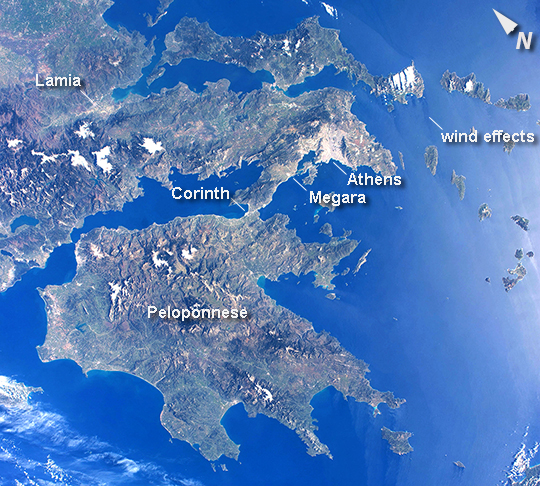 |
| The Peloponnese This photo from an astronaut on the International Space Station shows much of the nation of Greece. The urban region of Athens is recognizable due to its size and light tone compared to the surrounding landscape; the smaller cities of Megara and Lamia also stand out. Dark-toned mountains with snow-covered peaks contrast with warmer, greener valleys where agriculture takes place. The intense blue of the Mediterranean Sea fades near the Sun's reflection point along the right side of the image, and numerous wind streaks in the lee of the islands become visible. The Peloponnese - home in ancient times to the city-state of Sparta - is the great peninsula separated from the mainland by the narrow isthmus of Corinth. Several times over the centuries these narrows have acted as a defensive point against attack from the mainland. More recently in 1893, the narrows provided a point of connection when a ship canal was excavated between the gulfs to the west and to the east. |
| Images: | All Available Images Low-Resolution 399k |
|
| Mission: | ISS039 |
|
| Roll - Frame: | E - 3505 |
|
| Geographical Name: | GREECE |
|
| Features: | PELOPONNESE, ATHENS, MEDITERRANEAN SEA |
|
| Center Lat x Lon: | 37.0N x 22.0E |
|
| Film Exposure: | N=Normal exposure, U=Under exposed, O=Over exposed, F=out of Focus |
|
| Percentage of Cloud Cover-CLDP: | 10 |
|
| Camera:: | N5 |
|
| Camera Tilt: | 18 | LO=Low Oblique, HO=High Oblique, NV=Near Vertical |
| Camera Focal Length: | 28 |
|
| Nadir to Photo Center Direction: | SW | The direction from the nadir to the center point, N=North, S=South, E=East, W=West |
| Stereo?: | Y=Yes there is an adjacent picture of the same area, N=No there isn't |
|
| Orbit Number: | |
|
| Date: | 20140321 | YYYYMMDD |
| Time: | 074337 | GMT HHMMSS |
| Nadir Lat: | 37.8N |
Latitude of suborbital point of spacecraft |
| Nadir Lon: | 22.9E |
Longitude of suborbital point of spacecraft |
| Sun Azimuth: | 123 | Clockwise angle in degrees from north to the sun measured at the nadir point |
| Space Craft Altitude: | 222 | nautical miles |
| Sun Elevation: | 36 | Angle in degrees between the horizon and the sun, measured at the nadir point |
| Land Views: | ISLAND, PENINSULA |
|
| Water Views: | SEA |
|
| Atmosphere Views: | |
|
| Man Made Views: | |
|
| City Views: | ATHENS |
|
Photo is not associated with any sequences | ||
| NASA Home Page |
JSC Home Page |
JSC Digital Image Collection |
Earth Science & Remote Sensing |
|
This service is provided by the International Space Station program and the JSC Earth Science & Remote Sensing Unit, ARES Division, Exploration Integration Science Directorate.

|