Geographic Region: RUSSIAN FEDERATION
Feature: OKHOTSK SEA, KURIL ISLANDS, ICE, HAZE
|
Geographic Region: RUSSIAN FEDERATION Feature: OKHOTSK SEA, KURIL ISLANDS, ICE, HAZE |
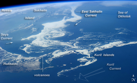 |
| Sea of Okhotsk ice, Northern Japan Patterns of sea ice in a spring panorama of the Sea of Okhotsk are featured in this image from the International Space Station. The image reveals dynamics of ocean currents that are otherwise difficult to visualize. Here we see nearly 1000 km of the East Sakhalin Current carrying winter ice south toward Japan's Hokkaido Island. The current is indicated by the narrow corridor of dense ice that hugs the coast of Sakhalin Island--slightly obscured under haze at image top left. Reaching the barrier of Hokkaido, the ice patterns show a series of eddies and swirls (image center). The current then turns and transports ice along the Kuril Island chain. Some ice spills through gaps where it is swept southwest by the Kuril Current (image lower right). The East Sakhalin Current dies back in summer when the Soya Current (arrow far left) begins to enter the Sea of Okhotsk. This inrush of summer water starts in April (when this image was taken) and probably appears in the image as the ice pattern bulging to the east (between the small arrows). Volcanic cones can be seen along the Kuril Islands (image bottom right), a continuation of the volcanic line of Hokkaido. Atmospheric haze (top left and upper margin) is likely industrial smog from China and Japan, made more visible at the top of the image by the oblique viewing angle. |
| Images: | All Available Images Low-Resolution 215k |
|
| Mission: | ISS039 |
|
| Roll - Frame: | E - 11773 |
|
| Geographical Name: | RUSSIAN FEDERATION |
|
| Features: | OKHOTSK SEA, KURIL ISLANDS, ICE, HAZE |
|
| Center Lat x Lon: | 45.0N x 146.5E |
|
| Film Exposure: | N=Normal exposure, U=Under exposed, O=Over exposed, F=out of Focus |
|
| Percentage of Cloud Cover-CLDP: | 10 |
|
| Camera:: | N5 |
|
| Camera Tilt: | HO | LO=Low Oblique, HO=High Oblique, NV=Near Vertical |
| Camera Focal Length: | 80 |
|
| Nadir to Photo Center Direction: | W | The direction from the nadir to the center point, N=North, S=South, E=East, W=West |
| Stereo?: | Y=Yes there is an adjacent picture of the same area, N=No there isn't |
|
| Orbit Number: | |
|
| Date: | 20140414 | YYYYMMDD |
| Time: | 064530 | GMT HHMMSS |
| Nadir Lat: | 41.5N |
Latitude of suborbital point of spacecraft |
| Nadir Lon: | 156.7E |
Longitude of suborbital point of spacecraft |
| Sun Azimuth: | 269 | Clockwise angle in degrees from north to the sun measured at the nadir point |
| Space Craft Altitude: | 220 | nautical miles |
| Sun Elevation: | 15 | Angle in degrees between the horizon and the sun, measured at the nadir point |
| Land Views: | COAST, ISLAND |
|
| Water Views: | ICE, OCEAN, SEA, SEA ICE |
|
| Atmosphere Views: | HAZE, SMOG |
|
| Man Made Views: | |
|
| City Views: | |
|
Photo is not associated with any sequences | ||
| NASA Home Page |
JSC Home Page |
JSC Digital Image Collection |
Earth Science & Remote Sensing |
|
This service is provided by the International Space Station program and the JSC Earth Science & Remote Sensing Unit, ARES Division, Exploration Integration Science Directorate.

|