
Geographic Region: USA-TEXAS
Feature: INTRACOASTAL WATERWAY, PORT ARANSAS
|
Geographic Region: USA-TEXAS Feature: INTRACOASTAL WATERWAY, PORT ARANSAS |
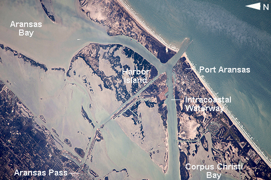 |
| Port Aransas and the Intracoastal Waterway, Texas This image from the International Space Station shows 18 km (11.2 mi) of Intracoastal Waterway, the 4800 km-long (3000 mi) barge channel that lies on the protected inshore of the coastal islands of the southern and eastern USA, including coastal Texas. The small city of Port Aransas lies on a barrier island fully 18 km (11.2 mi) seaward of the mainland and its sister city, Aransas Pass (image lower left). This image shows parts of the waterway that are artificial, as in the straight sector leading into Corpus Christi Bay. (Corpus Christi lies outside the lower margin of the image.) Other sectors of the waterway are natural bays such as Aransas Bay. Jetties protect the inlet into the Gulf of Mexico (image top right). Inlets at many points cut through the barrier islands to give shipping access to the Gulf of Mexico and the Atlantic Ocean. Several large rivers allow access from the waterway to distant inland ports, as in the cases of the Mississippi and Hudson Rivers. A recent study concluded that barge shipment in the Gulf Coast sector of the waterway remains the least-cost alternative for many commodities, with petroleum and petroleum products amounting to 30% of the total tonnage. |
| Images: | All Available Images Low-Resolution 316k |
|
| Mission: | ISS038 |
|
| Roll - Frame: | E - 57806 |
|
| Geographical Name: | USA-TEXAS |
|
| Features: | INTRACOASTAL WATERWAY, PORT ARANSAS |
|
| Center Lat x Lon: | 27.9N x 97.1W |
|
| Film Exposure: | N=Normal exposure, U=Under exposed, O=Over exposed, F=out of Focus |
|
| Percentage of Cloud Cover-CLDP: | 10 |
|
| Camera:: | N4 |
|
| Camera Tilt: | 33 | LO=Low Oblique, HO=High Oblique, NV=Near Vertical |
| Camera Focal Length: | 1000 |
|
| Nadir to Photo Center Direction: | SE | The direction from the nadir to the center point, N=North, S=South, E=East, W=West |
| Stereo?: | Y=Yes there is an adjacent picture of the same area, N=No there isn't |
|
| Orbit Number: | |
|
| Date: | 20140221 | YYYYMMDD |
| Time: | 190100 | GMT HHMMSS |
| Nadir Lat: | 30.0N |
Latitude of suborbital point of spacecraft |
| Nadir Lon: | 98.3W |
Longitude of suborbital point of spacecraft |
| Sun Azimuth: | 185 | Clockwise angle in degrees from north to the sun measured at the nadir point |
| Space Craft Altitude: | 223 | nautical miles |
| Sun Elevation: | 50 | Angle in degrees between the horizon and the sun, measured at the nadir point |
| Land Views: | COAST, ISLAND |
|
| Water Views: | BAY, CHANNEL, INLET |
|
| Atmosphere Views: | |
|
| Man Made Views: | |
|
| City Views: | |
|
Photo is not associated with any sequences | ||
| NASA Home Page |
JSC Home Page |
JSC Digital Image Collection |
Earth Science & Remote Sensing |
|
This service is provided by the International Space Station program and the JSC Earth Science & Remote Sensing Unit, ARES Division, Exploration Integration Science Directorate.

|