
Geographic Region: IRAN
Feature: KAVIR DESERT, LAKE BEDS
|
Geographic Region: IRAN Feature: KAVIR DESERT, LAKE BEDS |
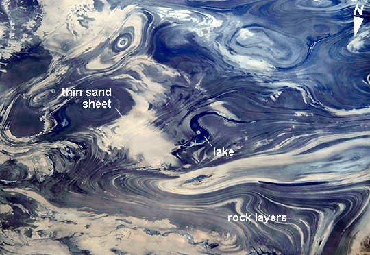 |
| Kavir Desert, Iran This striking pattern of numerous parallel lines and sweeping curves greets orbiting observers in the International Space Station as they pass over the deserts of central Iran. The lack of soil and vegetation allows the geological structure of the rocks to appear quite clearly. The patterns result from the gentle folding of numerous, thin, light and dark layers of rock. Later erosion by wind and water cut a flat surface across the folds, not only exposing hundreds of layers but also showing the shapes of the folds. The pattern has been likened to the layers of a sliced onion. The dark water of a lake (image center) occupies a depression in a more easily eroded, S-shaped layer of rock. The irregular light-toned patch just left of the lake is a sand sheet thin enough to allow the underlying rock layers to be detected. A small river snakes across the bottom of the image. In this desert landscape there are no fields or roads to give a sense of scale. In fact, the image width represents a distance of 84 km. |
| Images: | All Available Images Low-Resolution 340k |
|
| Mission: | ISS038 |
|
| Roll - Frame: | E - 47388 |
|
| Geographical Name: | IRAN |
|
| Features: | KAVIR DESERT, LAKE BEDS |
|
| Center Lat x Lon: | 34.8N x 55.0E |
|
| Film Exposure: | N=Normal exposure, U=Under exposed, O=Over exposed, F=out of Focus |
|
| Percentage of Cloud Cover-CLDP: | 10 |
|
| Camera:: | N3 |
|
| Camera Tilt: | 52 | LO=Low Oblique, HO=High Oblique, NV=Near Vertical |
| Camera Focal Length: | 200 |
|
| Nadir to Photo Center Direction: | SW | The direction from the nadir to the center point, N=North, S=South, E=East, W=West |
| Stereo?: | Y=Yes there is an adjacent picture of the same area, N=No there isn't |
|
| Orbit Number: | |
|
| Date: | 20140214 | YYYYMMDD |
| Time: | 121620 | GMT HHMMSS |
| Nadir Lat: | 38.5N |
Latitude of suborbital point of spacecraft |
| Nadir Lon: | 57.9E |
Longitude of suborbital point of spacecraft |
| Sun Azimuth: | 239 | Clockwise angle in degrees from north to the sun measured at the nadir point |
| Space Craft Altitude: | 221 | nautical miles |
| Sun Elevation: | 15 | Angle in degrees between the horizon and the sun, measured at the nadir point |
| Land Views: | DESERT |
|
| Water Views: | LAKE, RIVER |
|
| Atmosphere Views: | |
|
| Man Made Views: | |
|
| City Views: | |
|
Photo is not associated with any sequences | ||
| NASA Home Page |
JSC Home Page |
JSC Digital Image Collection |
Earth Science & Remote Sensing |
|
This service is provided by the International Space Station program and the JSC Earth Science & Remote Sensing Unit, ARES Division, Exploration Integration Science Directorate.

|