Geographic Region: REPUBLIC SOUTH AFRICA
Feature: SWARTBERG MTS., PRINCE ALBERT
|
Geographic Region: REPUBLIC SOUTH AFRICA Feature: SWARTBERG MTS., PRINCE ALBERT |
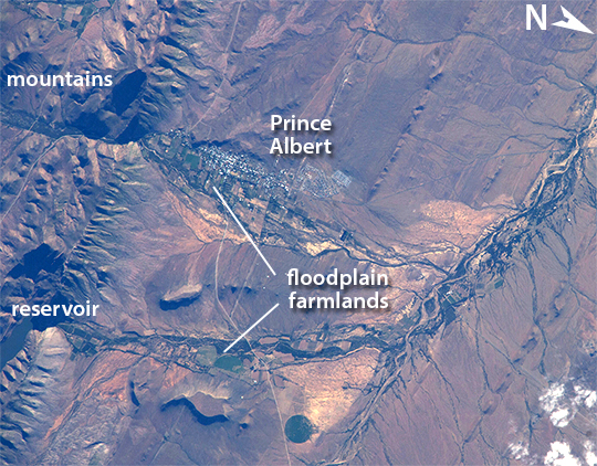 |
| Prince Albert, Western Cape, South Africa ISS crews sometimes take detailed images with an 800 millimeter lens, such as this view of the small town of Prince Albert, South Africa. The town (population about 7,000) lies about 355 kilometers (220 miles) east of Cape Town, at the foot of the mountains known as the Great Swartberg. Prince Albert, named after Queen Victoria's husband, appears as a cluster of whitewashed buildings (image left) at the foot of the mountains, with larger dwellings nearer the steep mountain front and smaller dwellings further away. Though Prince Albert is small and the climate is a dry, the water supply from gorges immediately upstream (a small reservoir appears on the left) have made the town well-known as a productive point in the Karoo semidesert. Olive groves and other crops flourish on the valleys floors, surrounded by sheep and ostrich ranches. Founded 250 years ago, this small town retains more than a dozen registered historic buildings in the Victorian and Cape Dutch styles. It is one of several small Karoo towns that have become getaways from South Africa's large, crowded cities; tourism has developed significantly in the past 20 years. Swartberg means Black Mountain in Afrikaans, and winter snow (not visible in this image) along the mountain tops makes for spectacular scenery. The mountains - standing 1,370 to 1,980 meters (4,500 to 6,500 feet) above the town - are part of the ancient Cape Fold Mountain Belt. Gorges through the mountains provide impressive side-on views of tightly folded and broken rock layers associated with the mountain-building episode. |
| Images: | All Available Images Low-Resolution 384k |
|
| Mission: | ISS038 |
|
| Roll - Frame: | E - 39032 |
|
| Geographical Name: | REPUBLIC SOUTH AFRICA |
|
| Features: | SWARTBERG MTS., PRINCE ALBERT |
|
| Center Lat x Lon: | 33.2S x 22.0E |
|
| Film Exposure: | N=Normal exposure, U=Under exposed, O=Over exposed, F=out of Focus |
|
| Percentage of Cloud Cover-CLDP: | 10 |
|
| Camera:: | N5 |
|
| Camera Tilt: | HO | LO=Low Oblique, HO=High Oblique, NV=Near Vertical |
| Camera Focal Length: | 800 |
|
| Nadir to Photo Center Direction: | SW | The direction from the nadir to the center point, N=North, S=South, E=East, W=West |
| Stereo?: | Y=Yes there is an adjacent picture of the same area, N=No there isn't |
|
| Orbit Number: | |
|
| Date: | 20140130 | YYYYMMDD |
| Time: | 160105 | GMT HHMMSS |
| Nadir Lat: | 28.6S |
Latitude of suborbital point of spacecraft |
| Nadir Lon: | 25.8E |
Longitude of suborbital point of spacecraft |
| Sun Azimuth: | 258 | Clockwise angle in degrees from north to the sun measured at the nadir point |
| Space Craft Altitude: | 228 | nautical miles |
| Sun Elevation: | 14 | Angle in degrees between the horizon and the sun, measured at the nadir point |
| Land Views: | MOUNTAIN |
|
| Water Views: | RESERVOIR |
|
| Atmosphere Views: | |
|
| Man Made Views: | |
|
| City Views: | CAPE TOWN |
|
Photo is not associated with any sequences | ||
| NASA Home Page |
JSC Home Page |
JSC Digital Image Collection |
Earth Science & Remote Sensing |
|
This service is provided by the International Space Station program and the JSC Earth Science & Remote Sensing Unit, ARES Division, Exploration Integration Science Directorate.

|