 Photo #: ISS038-E-38300 Date: Jan. 2014
Geographic Region: NORTH KOREA
Feature: PAN--NORTH & SOUTH KOREA AT NIGHT
|
Photo #: ISS038-E-38300 Date: Jan. 2014 Geographic Region: NORTH KOREA Feature: PAN--NORTH & SOUTH KOREA AT NIGHT |
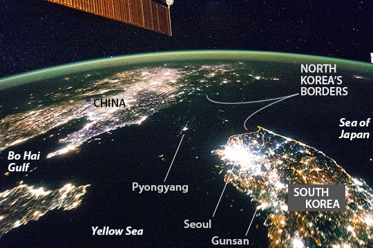 |
| The Koreas at Night Flying over East Asia, astronauts on the International Space Station (ISS) took this night image of the Korean Peninsula. Unlike daylight images, city lights at night illustrate dramatically the relative economic importance of cities, as gauged by relative size. In this north-looking view, it is immediately obvious that greater Seoul is a major city and that the port of Gunsan is minor by comparison. There are 25.6 million people in the Seoul metropolitan area - more than half of South Korea's citizens - while Gunsan's population is 280,000. North Korea is almost completely dark compared to neighboring South Korea and China. The darkened land appears as if it were a patch of water joining the Yellow Sea to the Sea of Japan. Its capital city, Pyongyang, appears like a small island, despite a population of 3.26 million (as of 2008). The light emission from Pyongyang is equivalent to the smaller towns in South Korea. Coastlines are often very apparent in night imagery, as shown by South Korea's eastern shoreline. But the coast of North Korea is difficult to detect. These differences are illustrated in per capita power consumption in the two countries, with South Korea at 10,162 kilowatt hours and North Korea at 739 kilowatt hours. You can view time-lapse videos of East Asia, as viewed from the ISS on January 30, 2014, by clicking here (standard resolution) and here (high-definition). |
| Images: | All Available Images Low-Resolution 275k |
|
| Mission: | ISS038 |
|
| Roll - Frame: | E - 38300 |
|
| Geographical Name: | NORTH KOREA |
|
| Features: | PAN--NORTH & SOUTH KOREA AT NIGHT |
|
| Center Lat x Lon: | 39.0N x 125.5E |
|
| Film Exposure: | N=Normal exposure, U=Under exposed, O=Over exposed, F=out of Focus |
|
| Percentage of Cloud Cover-CLDP: | 10 |
|
| Camera:: | N5 |
|
| Camera Tilt: | HO | LO=Low Oblique, HO=High Oblique, NV=Near Vertical |
| Camera Focal Length: | 24 |
|
| Nadir to Photo Center Direction: | N | The direction from the nadir to the center point, N=North, S=South, E=East, W=West |
| Stereo?: | Y=Yes there is an adjacent picture of the same area, N=No there isn't |
|
| Orbit Number: | |
|
| Date: | 20140130 | YYYYMMDD |
| Time: | 131618 | GMT HHMMSS |
| Nadir Lat: | 33.0N |
Latitude of suborbital point of spacecraft |
| Nadir Lon: | 123.8E |
Longitude of suborbital point of spacecraft |
| Sun Azimuth: | 283 | Clockwise angle in degrees from north to the sun measured at the nadir point |
| Space Craft Altitude: | 222 | nautical miles |
| Sun Elevation: | -51 | Angle in degrees between the horizon and the sun, measured at the nadir point |
| Land Views: | COAST, PENINSULA |
|
| Water Views: | |
|
| Atmosphere Views: | |
|
| Man Made Views: | |
|
| City Views: | PYONGYANG, SEOUL |
|
Photo is not associated with any sequences | ||
| NASA Home Page |
JSC Home Page |
JSC Digital Image Collection |
Earth Science & Remote Sensing |
|
This service is provided by the International Space Station program and the JSC Earth Science & Remote Sensing Unit, ARES Division, Exploration Integration Science Directorate.

|