Geographic Region: KERGUELEN ILES
Feature: POSSESSION I., EAST I., ILE AUX COCHONS
|
Geographic Region: KERGUELEN ILES Feature: POSSESSION I., EAST I., ILE AUX COCHONS |
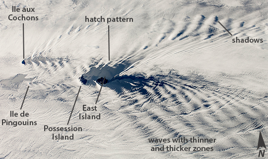 |
| Possession Island, East Island and cloud patterns This wide field-of-view image taken by astronauts in the the International Space Station, shows an east-west swath of the southwestern Indian Ocean. Two remote islands, part of the French Southern and Antarctic Lands, appear in the center of the image. Possession Island and East Island are both only 18 km long. A smaller island, Ile aux Cochons (Pigs Island), lies 100 km to the west. Each island has set up V-shaped trains of waves, like bow waves, as the air flows over the islands from the west. The bow-wave patterns are overlaid on the low regional stratus (blanket) cloud that is so common in the southern Indian Ocean at 50ᵒ South latitude. This view was taken from more than 400 km above the sea surface and reveals relationships that could not be readily understood by someone standing on one of the islands. For example, larger and higher islands produce larger waves. So the largest are being generated by Possession Island (934 m above sea level at the highest point), and East Island, versus much smaller waves developed downwind of the tiny Ile de Pingouins (340 m asl high, invisible below the cloud deck). Other patterns also can be detected. Waves in an upper layer can be seen casting shadows onto a lower layer. In the upper half of the image the waves are making thicker and thinner zones in the clouds of the lower layer. Wave trains from Possession Island and Ile aux Cochons are interacting in a cross-hatch pattern. Wave clouds generated by Ile aux Cochons were captured by astronauts in 2012 in a more detailed view (taken with a 180 mm focal-length lens, compared with this wide 28 mm lens view). All three islands in the view have been designated IBA's (Important Bird Areas) because they are breeding sites for numerous species of seabird. Interestingly, the pigs introduced to Ile aux Cochons are now eradicated to help protect the bird habitats. Introduced goats have been eradicated on Possession Island, but rats remain and prey on smaller birds, and these species now nest at higher elevations for protection. |
| Images: | All Available Images Low-Resolution 229k |
|
| Mission: | ISS038 |
|
| Roll - Frame: | E - 36501 |
|
| Geographical Name: | KERGUELEN ILES |
|
| Features: | POSSESSION I., EAST I., ILE AUX COCHONS |
|
| Center Lat x Lon: | 46.5S x 53.0E |
|
| Film Exposure: | N=Normal exposure, U=Under exposed, O=Over exposed, F=out of Focus |
|
| Percentage of Cloud Cover-CLDP: | 100 |
|
| Camera:: | N2 |
|
| Camera Tilt: | HO | LO=Low Oblique, HO=High Oblique, NV=Near Vertical |
| Camera Focal Length: | 28 |
|
| Nadir to Photo Center Direction: | W | The direction from the nadir to the center point, N=North, S=South, E=East, W=West |
| Stereo?: | Y=Yes there is an adjacent picture of the same area, N=No there isn't |
|
| Orbit Number: | |
|
| Date: | 20140128 | YYYYMMDD |
| Time: | 124958 | GMT HHMMSS |
| Nadir Lat: | 45.3S |
Latitude of suborbital point of spacecraft |
| Nadir Lon: | 59.0E |
Longitude of suborbital point of spacecraft |
| Sun Azimuth: | 272 | Clockwise angle in degrees from north to the sun measured at the nadir point |
| Space Craft Altitude: | 228 | nautical miles |
| Sun Elevation: | 28 | Angle in degrees between the horizon and the sun, measured at the nadir point |
| Land Views: | ISLAND |
|
| Water Views: | OCEAN, WAVE |
|
| Atmosphere Views: | |
|
| Man Made Views: | |
|
| City Views: | |
|
Photo is not associated with any sequences | ||
| NASA Home Page |
JSC Home Page |
JSC Digital Image Collection |
Earth Science & Remote Sensing |
|
This service is provided by the International Space Station program and the JSC Earth Science & Remote Sensing Unit, ARES Division, Exploration Integration Science Directorate.

|