Geographic Region: USA-ALASKA
Feature: ISLANDS OF THE FOUR MOUNTAINS,CLEVELAND VOLCANO,CARLISLE VOLCANO,SNOW
|
Geographic Region: USA-ALASKA Feature: ISLANDS OF THE FOUR MOUNTAINS,CLEVELAND VOLCANO,CARLISLE VOLCANO,SNOW |
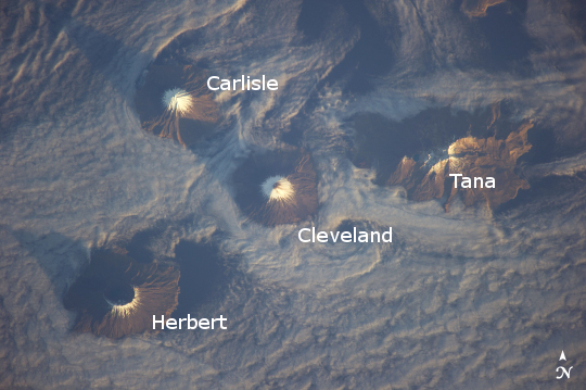 |
| Islands of the Four Mountains, Aleutian Islands Note: This caption refers to the image versions labeled "NASA's Earth Observatory web site". Morning sunlight illuminates the southeast-facing slopes of the Islands of the Four Mountains in this astronaut photograph from the International Space Station. The islands, part of the Aleutian Island chain, are actually the upper slopes of volcanoes rising from the sea floor; Carlisle, Cleveland, Herbert, and Tana. Carlisle and Herbert volcanoes are distinct cones and form separate islands. Cleveland volcano and the Tana volcanic complex form the eastern and western ends respectively of Chuginadak Island; a cloud bank obscures the connecting land mass in this image. Cleveland volcano (peak elevation 1730 meters above sea level, or asl) is one of the most active in the Aleutian chain, with its most recent activity--eruptions and lava flow emplacement--taking place in May of 2013 (crew aboard the ISS captured an earlier eruption in 2006). The northernmost of the islands, Carlisle volcano's (peak elevation 1620 meters asl) last confirmed eruption occurred in 1828, with unconfirmed reports of activity in 1987. Herbert volcano (peak elevation 1280 meters asl) to the southwest displays a classic cone structure breached by a 2-kilometer wide summit caldera (image lower left), but there are no historical records of volcanic activity. The easternmost peak, Tana (1170 meters asl) is a volcanic complex comprised of two east-west trending volcanoes and associated younger cinder cones; like Herbert volcano, there is no historical record of activity at Tana. A layer of low cloud and/or fog obscures much of the lower elevations of the islands and the sea surface, but the clouds also indicate the general airflow pattern around and through the islands. Directly to the south-southeast of Cleveland volcano a Von Karman vortex street is visible. Shadows cast by the morning sun extend from the peaks towards the northwest. The peaks of all of the Four Islands have snow cover; this is distinct from the clouds due to both higher brightness (white versus gray) and specific location on the landscape. |
| Images: | All Available Images Low-Resolution 205k |
|
| Mission: | ISS038 |
|
| Roll - Frame: | E - 3612 |
|
| Geographical Name: | USA-ALASKA |
|
| Features: | ISLANDS OF THE FOUR MOUNTAINS,CLEVELAND VOLCANO,CARLISLE VOLCANO,SNOW |
|
| Center Lat x Lon: | 52.8N x 169.9W |
|
| Film Exposure: | N=Normal exposure, U=Under exposed, O=Over exposed, F=out of Focus |
|
| Percentage of Cloud Cover-CLDP: | 75 |
|
| Camera:: | N5 |
|
| Camera Tilt: | 29 | LO=Low Oblique, HO=High Oblique, NV=Near Vertical |
| Camera Focal Length: | 400 |
|
| Nadir to Photo Center Direction: | NW | The direction from the nadir to the center point, N=North, S=South, E=East, W=West |
| Stereo?: | Y=Yes there is an adjacent picture of the same area, N=No there isn't |
|
| Orbit Number: | |
|
| Date: | 20131115 | YYYYMMDD |
| Time: | 193742 | GMT HHMMSS |
| Nadir Lat: | 51.0N |
Latitude of suborbital point of spacecraft |
| Nadir Lon: | 168.9W |
Longitude of suborbital point of spacecraft |
| Sun Azimuth: | 132 | Clockwise angle in degrees from north to the sun measured at the nadir point |
| Space Craft Altitude: | 221 | nautical miles |
| Sun Elevation: | 8 | Angle in degrees between the horizon and the sun, measured at the nadir point |
| Land Views: | CALDERA, ISLAND, VOLCANO |
|
| Water Views: | |
|
| Atmosphere Views: | FOG, VON KARMAN VORTEX |
|
| Man Made Views: | |
|
| City Views: | |
|
Photo is not associated with any sequences | ||
| NASA Home Page |
JSC Home Page |
JSC Digital Image Collection |
Earth Science & Remote Sensing |
|
This service is provided by the International Space Station program and the JSC Earth Science & Remote Sensing Unit, ARES Division, Exploration Integration Science Directorate.

|