
Geographic Region: USA-UTAH
Feature: GREEN RIVER, BOWKNOT BEND, CONTRAIL
|
Geographic Region: USA-UTAH Feature: GREEN RIVER, BOWKNOT BEND, CONTRAIL |
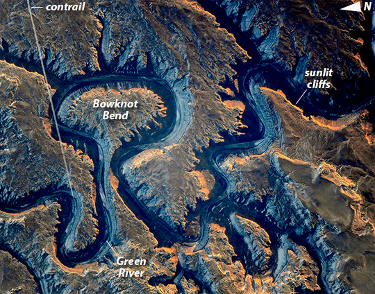 |
| This sector of the Green River canyon in eastern Utah is known as Bowknot Bend because of the way the river doubles back on itself. The loop carries river rafters 14.5 kilometers (9 miles) before bringing them back to nearly the same point they started from--though on the other side of a low, narrow saddle (image center). In this photograph taken by an astronaut on the International Space Station, the Green River appears dark because it lies in deep shadow, 300 meters (1,000 feet) below the surrounding landscape. The yellow-tinged cliffs that face the rising sun give a sense of the steep canyon walls. The straight white line across the scene is the contrail from a jet liner that passed over Bowknot Bend. Note that north is to the bottom of the image. The reason for the tight bends in the Green River is the same as it is for the Mississippi: river courses often wind over time when they flow across a bed of relatively soft sediment in a floodplain. Geologists assume that the Green River, before its present canyon phase, once snaked across a wide valley on a bed of its own sediment and made a series of striking meander bends. Vertical uplift of the entire landscape--by deep-seated tectonic forces related to the growth of the Rocky Mountains--caused the Green River to erode downwards into the hard rocks under the valley. In the process, the present vertical-sided canyon was formed, preserving the tight loops reminiscent of an earlier time. Bowknot was named by geologist John Wesley Powell in 1869 during one of his famous explorations of the rivers in the American West. The Green River flows south (toward the top of this image) and joins the Colorado River downstream. The combined flow of these rivers was responsible for cutting the Grand Canyon, some 325 kilometers (200 miles) away from Bowknot. |
| Images: | All Available Images Low-Resolution 461k |
|
| Mission: | ISS038 |
|
| Roll - Frame: | E - 35416 |
|
| Geographical Name: | USA-UTAH |
|
| Features: | GREEN RIVER, BOWKNOT BEND, CONTRAIL |
|
| Center Lat x Lon: | 38.6N x 110W |
|
| Film Exposure: | N=Normal exposure, U=Under exposed, O=Over exposed, F=out of Focus |
|
| Percentage of Cloud Cover-CLDP: | 10 |
|
| Camera:: | N4 |
|
| Camera Tilt: | 14 | LO=Low Oblique, HO=High Oblique, NV=Near Vertical |
| Camera Focal Length: | 1000 |
|
| Nadir to Photo Center Direction: | W | The direction from the nadir to the center point, N=North, S=South, E=East, W=West |
| Stereo?: | Y=Yes there is an adjacent picture of the same area, N=No there isn't |
|
| Orbit Number: | |
|
| Date: | 20140122 | YYYYMMDD |
| Time: | 151740 | GMT HHMMSS |
| Nadir Lat: | 38.6N |
Latitude of suborbital point of spacecraft |
| Nadir Lon: | 109.1W |
Longitude of suborbital point of spacecraft |
| Sun Azimuth: | 122 | Clockwise angle in degrees from north to the sun measured at the nadir point |
| Space Craft Altitude: | 222 | nautical miles |
| Sun Elevation: | 8 | Angle in degrees between the horizon and the sun, measured at the nadir point |
| Land Views: | |
|
| Water Views: | RIVER |
|
| Atmosphere Views: | |
|
| Man Made Views: | CONTRAIL |
|
| City Views: | |
|
Photo is not associated with any sequences | ||
| NASA Home Page |
JSC Home Page |
JSC Digital Image Collection |
Earth Science & Remote Sensing |
|
This service is provided by the International Space Station program and the JSC Earth Science & Remote Sensing Unit, ARES Division, Exploration Integration Science Directorate.

|