
Geographic Region: IRAN
Feature: BAZMAN VOLCANO,LAVA FLOWS,RADIAL DRAINAGE PATTERN
|
Geographic Region: IRAN Feature: BAZMAN VOLCANO,LAVA FLOWS,RADIAL DRAINAGE PATTERN |
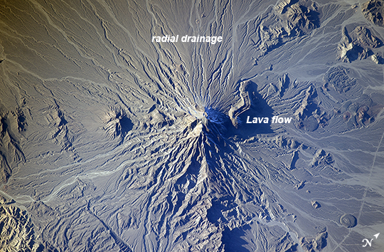 |
| Bazman Volcano, Iran Note: This caption refers to the image versions labeled "NASA's Earth Observatory web site". Bazman volcano is located in a remote region of southern Iran within the Bazman Protected Area of Sistan and Baluchestan Provinces. While the volcano has the classic cone shape associated with stratovolcanoes, it is also heavily dissected by channels that extend downwards from the 3490 meter above sea level summit. This radial drainage pattern - looking similar to the spokes of a bicycle wheel - is readily observed in this astronaut photograph from the International Space Station. Such patterns can form around high, symmetric peaks when water runoff and erosion is not constrained by the resistance of geologic materials or barriers to flow, leading to essentially even distribution of water runoff channels around the central peak. While there is no historical record of volcanism at Bazman, and no geologic record of eruptive activity within the past 10,000 years, some fumarolic activity - gas and steam emissions - have been reported, according to the Smithsonian Institution National Museum of Natural History's Global Volcanism Program. The summit of the volcano is marked by a well-formed explosion crater, and lava cones formed on the flanks of the main volcano are associated with well-preserved lava flows- a particularly striking example is visible on the north flank of Bazman at image center. Together, these observations and features are suggestive that Bazman may be a dormant, rather than extinct, volcano. |
| Images: | All Available Images Low-Resolution 346k |
|
| Mission: | ISS038 |
|
| Roll - Frame: | E - 25895 |
|
| Geographical Name: | IRAN |
|
| Features: | BAZMAN VOLCANO,LAVA FLOWS,RADIAL DRAINAGE PATTERN |
|
| Center Lat x Lon: | 28.1N x 60.0E |
|
| Film Exposure: | N=Normal exposure, U=Under exposed, O=Over exposed, F=out of Focus |
|
| Percentage of Cloud Cover-CLDP: | 10 |
|
| Camera:: | N5 |
|
| Camera Tilt: | HO | LO=Low Oblique, HO=High Oblique, NV=Near Vertical |
| Camera Focal Length: | 400 |
|
| Nadir to Photo Center Direction: | NW | The direction from the nadir to the center point, N=North, S=South, E=East, W=West |
| Stereo?: | Y=Yes there is an adjacent picture of the same area, N=No there isn't |
|
| Orbit Number: | |
|
| Date: | 20140105 | YYYYMMDD |
| Time: | 115031 | GMT HHMMSS |
| Nadir Lat: | 23.0N |
Latitude of suborbital point of spacecraft |
| Nadir Lon: | 63.8E |
Longitude of suborbital point of spacecraft |
| Sun Azimuth: | 236 | Clockwise angle in degrees from north to the sun measured at the nadir point |
| Space Craft Altitude: | 225 | nautical miles |
| Sun Elevation: | 16 | Angle in degrees between the horizon and the sun, measured at the nadir point |
| Land Views: | CRATER, VOLCANO |
|
| Water Views: | |
|
| Atmosphere Views: | |
|
| Man Made Views: | |
|
| City Views: | |
|
Photo is not associated with any sequences | ||
| NASA Home Page |
JSC Home Page |
JSC Digital Image Collection |
Earth Science & Remote Sensing |
|
This service is provided by the International Space Station program and the JSC Earth Science & Remote Sensing Unit, ARES Division, Exploration Integration Science Directorate.

|