
Geographic Region: USA-UTAH
Feature: SALT LAKE CITY METRO AREA AT NIGHT,WASATCH MOUNTAINS
|
Geographic Region: USA-UTAH Feature: SALT LAKE CITY METRO AREA AT NIGHT,WASATCH MOUNTAINS |
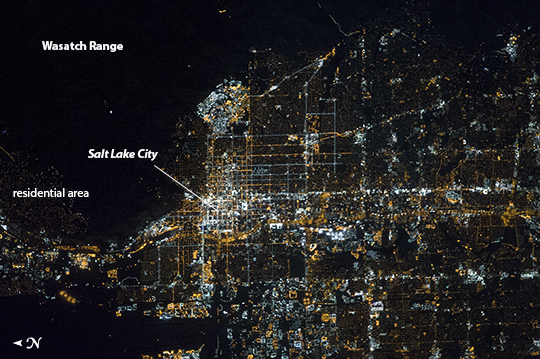 |
| Salt Lake City, Utah Metropolitan Area at Night The Salt Lake City metropolitan area is located along the western front of the Wasatch Range in northern Utah. Viewed at night from the vantage point of the International Space Station, the regular north-south and east-west layout of street grids typical of western US cities is clearly visible. Known as "the crossroads of the West", the headquarters of The Church of Jesus Christ of Latter-day Saints (also known as the LDS Church and informally as the Mormon Church), and the state capital of Utah Salt Lake City was founded in 1847 by Brigham Young together with other followers of the Mormon faith. The Salt Lake City metropolitan area today is included in the larger urban Wasatch Front region of Utah which includes over 2 million people (approximately 80% of the population of the state). Both the color of the city lights and their density provide clues to the character of the urban fabric - yellow gold lights generally indicate major roadways such as Interstate Highway 15 that passes through the center of the metropolitan area (image center, left to right), while bright white clusters of lights are associated with city centers, commercial, and industrial areas. In contrast, residential and suburban areas are recognizable due to diffuse and relatively dim lighting (image center left). The Wasatch Range to the east is largely dark, as are several large urban parks and golf courses located within the illuminated urban areas. |
| Images: | All Available Images Low-Resolution 284k |
|
| Mission: | ISS038 |
|
| Roll - Frame: | E - 16506 |
|
| Geographical Name: | USA-UTAH |
|
| Features: | SALT LAKE CITY METRO AREA AT NIGHT,WASATCH MOUNTAINS |
|
| Center Lat x Lon: | 40.8N x 111.9W |
|
| Film Exposure: | N=Normal exposure, U=Under exposed, O=Over exposed, F=out of Focus |
|
| Percentage of Cloud Cover-CLDP: | 10 |
|
| Camera:: | N5 |
|
| Camera Tilt: | 37 | LO=Low Oblique, HO=High Oblique, NV=Near Vertical |
| Camera Focal Length: | 600 |
|
| Nadir to Photo Center Direction: | W | The direction from the nadir to the center point, N=North, S=South, E=East, W=West |
| Stereo?: | Y=Yes there is an adjacent picture of the same area, N=No there isn't |
|
| Orbit Number: | |
|
| Date: | 20131212 | YYYYMMDD |
| Time: | 072742 | GMT HHMMSS |
| Nadir Lat: | 40.3N |
Latitude of suborbital point of spacecraft |
| Nadir Lon: | 109.2W |
Longitude of suborbital point of spacecraft |
| Sun Azimuth: | 13 | Clockwise angle in degrees from north to the sun measured at the nadir point |
| Space Craft Altitude: | 220 | nautical miles |
| Sun Elevation: | -73 | Angle in degrees between the horizon and the sun, measured at the nadir point |
| Land Views: | |
|
| Water Views: | |
|
| Atmosphere Views: | |
|
| Man Made Views: | HIGHWAY |
|
| City Views: | SALT LAKE CITY |
|
Photo is not associated with any sequences | ||
| NASA Home Page |
JSC Home Page |
JSC Digital Image Collection |
Earth Science & Remote Sensing |
|
This service is provided by the International Space Station program and the JSC Earth Science & Remote Sensing Unit, ARES Division, Exploration Integration Science Directorate.

|