 Photo #: ISS038-E-12569 Date: Dec. 2013
Geographic Region: ARGENTINA
Feature: SOLLIPULLI VOL., SNOW
|
Photo #: ISS038-E-12569 Date: Dec. 2013 Geographic Region: ARGENTINA Feature: SOLLIPULLI VOL., SNOW |
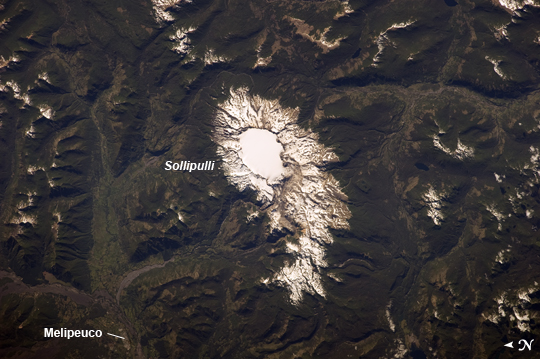 |
| Sollipulli Caldera, Chile and Argentina While active volcanoes are obvious targets of interest from the standpoint of natural hazards, there are some dormant volcanoes that nevertheless warrant concern due to their geologic history of activity. One such volcano is Sollipulli, located in central Chile near the border with Argentina in the southern Andes Mountains of South America. The volcano is located within the Parque Nacional Villarica of Chile. This astronaut photograph from the International Space Station highlights the summit (2282 meters above sea level) of the volcano and the bare slopes above the tree line. Lower elevations are covered with the green forests indicative of Southern Hemisphere summer. The summit of the volcano is occupied by a 4 kilometer wide caldera, currently filled with a snow-covered glacier (image center). While most calderas form following violent explosive eruptions, the types of volcanic rock and deposits associated with such an event have not been found at Sollipulli. The geologic evidence does indicate explosive activity 2900 years before present, and production of lava flows approximately 700 years before present. Together with craters and scoria cones located along the outer flanks of the caldera, this history suggests that Sollipulli could experience violent eruptions again, presenting an immediate potential hazard to such towns as Melipeuco in addition to the greater region. |
| Images: | All Available Images Low-Resolution 223k |
|
| Mission: | ISS038 |
|
| Roll - Frame: | E - 12569 |
|
| Geographical Name: | ARGENTINA |
|
| Features: | SOLLIPULLI VOL., SNOW |
|
| Center Lat x Lon: | 39S x 71.4W |
|
| Film Exposure: | N=Normal exposure, U=Under exposed, O=Over exposed, F=out of Focus |
|
| Percentage of Cloud Cover-CLDP: | 10 |
|
| Camera:: | N5 |
|
| Camera Tilt: | 32 | LO=Low Oblique, HO=High Oblique, NV=Near Vertical |
| Camera Focal Length: | 400 |
|
| Nadir to Photo Center Direction: | NW | The direction from the nadir to the center point, N=North, S=South, E=East, W=West |
| Stereo?: | Y=Yes there is an adjacent picture of the same area, N=No there isn't |
|
| Orbit Number: | |
|
| Date: | 20131206 | YYYYMMDD |
| Time: | 124524 | GMT HHMMSS |
| Nadir Lat: | 40.7S |
Latitude of suborbital point of spacecraft |
| Nadir Lon: | 69.8W |
Longitude of suborbital point of spacecraft |
| Sun Azimuth: | 87 | Clockwise angle in degrees from north to the sun measured at the nadir point |
| Space Craft Altitude: | 226 | nautical miles |
| Sun Elevation: | 40 | Angle in degrees between the horizon and the sun, measured at the nadir point |
| Land Views: | CALDERA, GLACIER, VOLCANO |
|
| Water Views: | |
|
| Atmosphere Views: | |
|
| Man Made Views: | |
|
| City Views: | |
|
Photo is not associated with any sequences | ||
| NASA Home Page |
JSC Home Page |
JSC Digital Image Collection |
Earth Science & Remote Sensing |

This service is provided by the International Space Station program and the JSC Earth Science & Remote Sensing Unit, ARES Division, Exploration Integration Science Directorate.

|