Geographic Region: ARGENTINA
Feature: SOUTHERN PATAGONIA ICEFIELD, UPSALA GL.
|
Geographic Region: ARGENTINA Feature: SOUTHERN PATAGONIA ICEFIELD, UPSALA GL. |
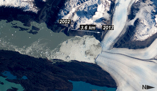 |
| Upsala Glacier Retreat, Patagonia Icefield, 2002-2013 Note: This caption refers to the image versions labeled "NASA's Earth Observatory web site". This astronaut photograph highlights the snout of the Upsala Glacier (49.88S 73.3W) on the Argentine side of the Southern Patagonian Icefield. Ice flow in this glacier (white mass, image right) is from the north (right). Dark lines of rocky moraine within the ice give a sense of the slow ice flow from right to left. A smaller side glacier joins Upsala at the present-day ice front--the wall from which masses of ice periodically collapse into Lake Argentino. In this image the 2.75 km-long wall casts a thin, dark shadow. The surface of Lake Argentino is whitened by a mass of ice debris from a recent collapse of the ice wall. Larger icebergs that have calved appear as white dots on the lake surface at image left. Remotely sensed data, including detailed astronaut images such as this, have recorded the position of the ice front over the years. Even though the ice actually flows slowly southward, comparison of this October 2013 image with older data (not shown) indicates that the ice wall of the glacier has moved backwards--upstream--an average of 3.6 km since early 2002. This so-called "retreat" is believed by scientists to indicate local climatic warming in this part of South America. The warming not only causes the ice front to retreat but more importantly, causes overall thinning of the glacier ice mass, as a study of 63 glaciers in Patagonia has shown is now a general trend (Rignot et al. 2003). Ice-front retreat is now known to be related to volumetric loss due to melting. Water color is related to glacier flow. Lake Argentino receives most of the ice from the glacier and thus also receives most of the "rock flour" (rocks ground to white powder by the ice scraping against the rock floor of the valley) from underneath the glacier. Glacial flour turns the lake water a gray-green hue in this image. The darker blue of the smaller lakes (image bottom) indicates that they are receiving much less rock flour. Rignot E, Rivera A, and Casassa G, 2003, Contribution of the Patagonia Icefields of South America to sea level rise. Science 302:434 - 437. |
| Images: | All Available Images Low-Resolution 219k |
|
| Mission: | ISS037 |
|
| Roll - Frame: | E - 5104 |
|
| Geographical Name: | ARGENTINA |
|
| Features: | SOUTHERN PATAGONIA ICEFIELD, UPSALA GL. |
|
| Center Lat x Lon: | 49.9S x 73.3W |
|
| Film Exposure: | N=Normal exposure, U=Under exposed, O=Over exposed, F=out of Focus |
|
| Percentage of Cloud Cover-CLDP: | 10 |
|
| Camera:: | N3 |
|
| Camera Tilt: | 29 | LO=Low Oblique, HO=High Oblique, NV=Near Vertical |
| Camera Focal Length: | 300 |
|
| Nadir to Photo Center Direction: | N | The direction from the nadir to the center point, N=North, S=South, E=East, W=West |
| Stereo?: | Y=Yes there is an adjacent picture of the same area, N=No there isn't |
|
| Orbit Number: | |
|
| Date: | 20131002 | YYYYMMDD |
| Time: | 174652 | GMT HHMMSS |
| Nadir Lat: | 51.8S |
Latitude of suborbital point of spacecraft |
| Nadir Lon: | 74.1W |
Longitude of suborbital point of spacecraft |
| Sun Azimuth: | 340 | Clockwise angle in degrees from north to the sun measured at the nadir point |
| Space Craft Altitude: | 228 | nautical miles |
| Sun Elevation: | 41 | Angle in degrees between the horizon and the sun, measured at the nadir point |
| Land Views: | GLACIER, VALLEY |
|
| Water Views: | ICE, LAKE |
|
| Atmosphere Views: | |
|
| Man Made Views: | |
|
| City Views: | |
|
Photo is not associated with any sequences | ||
| NASA Home Page |
JSC Home Page |
JSC Digital Image Collection |
Earth Science & Remote Sensing |
|
This service is provided by the International Space Station program and the JSC Earth Science & Remote Sensing Unit, ARES Division, Exploration Integration Science Directorate.

|