
Geographic Region: USA-CALIFORNIA
Feature: SAN FRANCISCO AT NIGHT, SAN JOSE, STOCKTON, MODESTO, SACRAMENTO
|
Geographic Region: USA-CALIFORNIA Feature: SAN FRANCISCO AT NIGHT, SAN JOSE, STOCKTON, MODESTO, SACRAMENTO |
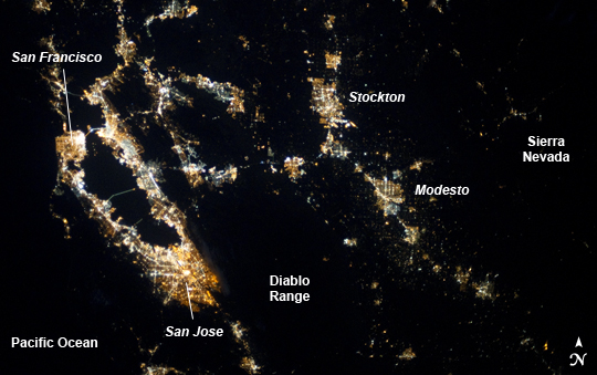 |
| San Francisco, CA Region at Night Note: This caption refers to the image versions labeled "NASA's Earth Observatory web site". This astronaut photograph from the International Space Station highlights the northern California region extending from the City of San Francisco and San Francisco Bay to the west, to the cities of Stockton, Modesto, and the Sierra Nevada to the east. At night, the city lights of the major metropolitan areas reflect some of the landscape controls that determine urban growth patterns in the region. The dark waters of San Francisco Bay are outlined by the lights of the cities of San Francisco to the west, San Jose to the southeast, and Oakland to the northeast (image left). Moving eastward from the Bay Area, the mountains of the Diablo Range present a largely dark region broken up by the lights of several smaller cities including Livermore, Walnut Creek, Concord, and Clayton (image upper left). The city lights of Stockton and Modesto mark the northern end of the San Joaquin Valley, a part of the Central Valley of California that extends for approximately 720 km (450 miles) northwest to southeast across much of the state. To the northeast of Modesto, city lights again become sparse as the mountains of the Sierra Nevada are encountered (image top right). |
| Images: | All Available Images Low-Resolution 178k |
|
| Mission: | ISS037 |
|
| Roll - Frame: | E - 2604 |
|
| Geographical Name: | USA-CALIFORNIA |
|
| Features: | SAN FRANCISCO AT NIGHT, SAN JOSE, STOCKTON, MODESTO, SACRAMENTO |
|
| Center Lat x Lon: | 38.0N x 122W |
|
| Film Exposure: | N=Normal exposure, U=Under exposed, O=Over exposed, F=out of Focus |
|
| Percentage of Cloud Cover-CLDP: | 10 |
|
| Camera:: | N5 |
|
| Camera Tilt: | 02 | LO=Low Oblique, HO=High Oblique, NV=Near Vertical |
| Camera Focal Length: | 50 |
|
| Nadir to Photo Center Direction: | SW | The direction from the nadir to the center point, N=North, S=South, E=East, W=West |
| Stereo?: | Y=Yes there is an adjacent picture of the same area, N=No there isn't |
|
| Orbit Number: | |
|
| Date: | 20130925 | YYYYMMDD |
| Time: | 083018 | GMT HHMMSS |
| Nadir Lat: | 38.1N |
Latitude of suborbital point of spacecraft |
| Nadir Lon: | 121.9W |
Longitude of suborbital point of spacecraft |
| Sun Azimuth: | 13 | Clockwise angle in degrees from north to the sun measured at the nadir point |
| Space Craft Altitude: | 220 | nautical miles |
| Sun Elevation: | -52 | Angle in degrees between the horizon and the sun, measured at the nadir point |
| Land Views: | RANGE, VALLEY |
|
| Water Views: | BAY |
|
| Atmosphere Views: | |
|
| Man Made Views: | |
|
| City Views: | CONCORD, LIVERMORE, OAKLAND, SAN FRANCISCO, SAN JOSE, STOCKTON |
|
Photo is not associated with any sequences | ||
| NASA Home Page |
JSC Home Page |
JSC Digital Image Collection |
Earth Science & Remote Sensing |
|
This service is provided by the International Space Station program and the JSC Earth Science & Remote Sensing Unit, ARES Division, Exploration Integration Science Directorate.

|