
Geographic Region: FRANCE
Feature: LE HAVRE,PORT COMPLEX,SEINE RIVER,ENGLISH CHANNEL
|
Geographic Region: FRANCE Feature: LE HAVRE,PORT COMPLEX,SEINE RIVER,ENGLISH CHANNEL |
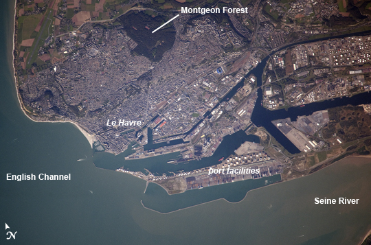 |
| Le Havre, France Note: This caption refers to the image versions labeled "NASA's Earth Observatory web site". The port city of Le Havre, France is located at the confluence of the Seine River and the English Channel along the northern coastline of the country (Upper Normandy region). Le Havre is the largest container port in France, and the second largest in terms of total traffic after Marseille. The extensive port facilities, visible at image center, include numerous docks (large cargo ships are clearly visible in this detailed astronaut photograph), storage tanks for petro- and other chemicals, and large industrial and warehouse facilities with white rooftops. The port also serves seagoing pleasure cruise vessels. The southern edge of the port facility along the Seine includes a seawall-enclosed ship turning area (image lower center). The Montgeon Forest, visible as a large green region at image upper center, includes 200 hectares of woodland and 30 hectares of meadows and lawns. The urban area of Le Havre, to the north of the port facilities, was largely destroyed during World War II. After the war, the city was rebuilt following the vision of architect Auguste Perret. Perret favored the use of reinforced and precast concrete in building structures, and much of the city built between 1945 and 1964 follows his plan in both form and materials - leading to the designation of Le Havre as a UNESCO World Heritage Site in 2005. |
| Images: | All Available Images Low-Resolution 242k |
|
| Mission: | ISS037 |
|
| Roll - Frame: | E - 21618 |
|
| Geographical Name: | FRANCE |
|
| Features: | LE HAVRE,PORT COMPLEX,SEINE RIVER,ENGLISH CHANNEL |
|
| Center Lat x Lon: | 49.5N x .1E |
|
| Film Exposure: | N=Normal exposure, U=Under exposed, O=Over exposed, F=out of Focus |
|
| Percentage of Cloud Cover-CLDP: | 10 |
|
| Camera:: | N4 |
|
| Camera Tilt: | 21 | LO=Low Oblique, HO=High Oblique, NV=Near Vertical |
| Camera Focal Length: | 1000 |
|
| Nadir to Photo Center Direction: | N | The direction from the nadir to the center point, N=North, S=South, E=East, W=West |
| Stereo?: | Y=Yes there is an adjacent picture of the same area, N=No there isn't |
|
| Orbit Number: | |
|
| Date: | 20131026 | YYYYMMDD |
| Time: | 133549 | GMT HHMMSS |
| Nadir Lat: | 48.1N |
Latitude of suborbital point of spacecraft |
| Nadir Lon: | 0.3W |
Longitude of suborbital point of spacecraft |
| Sun Azimuth: | 210 | Clockwise angle in degrees from north to the sun measured at the nadir point |
| Space Craft Altitude: | 222 | nautical miles |
| Sun Elevation: | 25 | Angle in degrees between the horizon and the sun, measured at the nadir point |
| Land Views: | FOREST |
|
| Water Views: | RIVER |
|
| Atmosphere Views: | |
|
| Man Made Views: | PORT, URBAN AREA |
|
| City Views: | LE HAVRE |
|
Photo is not associated with any sequences | ||
| NASA Home Page |
JSC Home Page |
JSC Digital Image Collection |
Earth Science & Remote Sensing |
|
This service is provided by the International Space Station program and the JSC Earth Science & Remote Sensing Unit, ARES Division, Exploration Integration Science Directorate.

|