
Geographic Region: USA-CONNECTICUT
Feature: NEW YORK METROPOLITAN AREA AT NIGHT,HARTFORD AT NIGHT,PROVIDENCE AT NIGHT
|
Geographic Region: USA-CONNECTICUT Feature: NEW YORK METROPOLITAN AREA AT NIGHT,HARTFORD AT NIGHT,PROVIDENCE AT NIGHT |
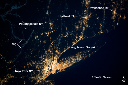 |
| Long Island Sound Region, USA at Night Long Island Sound is an estuary along the upper east coast of the USA, bounded by Long Island to the south (part of New York state), the coastline of Connecticut to the north, and the southeasternmost coastline of New York to the west. The Sound is well outlined by city and roadway lights in this night time astronaut photograph from the International Space Station (ISS). Both the water surface of Long Island Sound and the Atlantic Ocean are devoid of lights and appear dark, while several nearby metropolitan areas stand out due to their bright lighting. Directly to the west and southwest of the Sound, the New York, NY metropolitan area forms the brightest and most extensive area of lights. In terms of the extent of lighting, the metropolitan area seems largely recovered from the Hurricane Sandy storm event which effected the region in late October 2012. Further inland, the city lights of Poughkeepsie, NY are visible to the north of the New York, NY metro area. To the northeast, the urban centers of Hartford, CT and Providence, RI are visible at image upper right. The human-built traceries of light are accompanied by a natural phenomenon in the image - fog is visible along several river valleys throughout the region. Cold air streaming into the river valleys at night causes the local temperature to drop; fog develops when temperatures drop enough for water to condense from the air. The fog, appearing light blue-gray in the image, is likely illuminated from above by moonlight, and from below in urban areas built close to river channels (image left). |
| Images: | All Available Images Low-Resolution 215k |
|
| Mission: | ISS037 |
|
| Roll - Frame: | E - 1802 |
|
| Geographical Name: | USA-CONNECTICUT |
|
| Features: | NEW YORK METROPOLITAN AREA AT NIGHT,HARTFORD AT NIGHT,PROVIDENCE AT NIGHT |
|
| Center Lat x Lon: | 41.0N x 73.5W |
|
| Film Exposure: | N=Normal exposure, U=Under exposed, O=Over exposed, F=out of Focus |
|
| Percentage of Cloud Cover-CLDP: | 10 |
|
| Camera:: | N5 |
|
| Camera Tilt: | 35 | LO=Low Oblique, HO=High Oblique, NV=Near Vertical |
| Camera Focal Length: | 50 |
|
| Nadir to Photo Center Direction: | E | The direction from the nadir to the center point, N=North, S=South, E=East, W=West |
| Stereo?: | Y=Yes there is an adjacent picture of the same area, N=No there isn't |
|
| Orbit Number: | |
|
| Date: | 20130920 | YYYYMMDD |
| Time: | 075224 | GMT HHMMSS |
| Nadir Lat: | 41.8N |
Latitude of suborbital point of spacecraft |
| Nadir Lon: | 75.9W |
Longitude of suborbital point of spacecraft |
| Sun Azimuth: | 55 | Clockwise angle in degrees from north to the sun measured at the nadir point |
| Space Craft Altitude: | 220 | nautical miles |
| Sun Elevation: | -32 | Angle in degrees between the horizon and the sun, measured at the nadir point |
| Land Views: | COAST, ISLAND |
|
| Water Views: | ESTUARY, OCEAN, RIVER |
|
| Atmosphere Views: | FOG |
|
| Man Made Views: | |
|
| City Views: | HARTFORD, POUGHKEEPSIE, PROVIDENCE, NEW YORK |
|
Photo is not associated with any sequences | ||
| NASA Home Page |
JSC Home Page |
JSC Digital Image Collection |
Earth Science & Remote Sensing |
|
This service is provided by the International Space Station program and the JSC Earth Science & Remote Sensing Unit, ARES Division, Exploration Integration Science Directorate.

|