
Geographic Region: USA-TEXAS
Feature: HOUSTON AT NIGHT,AUSTIN AT NIGHT,SAN ANTONIO AT NIGHT, STORMS
|
Geographic Region: USA-TEXAS Feature: HOUSTON AT NIGHT,AUSTIN AT NIGHT,SAN ANTONIO AT NIGHT, STORMS |
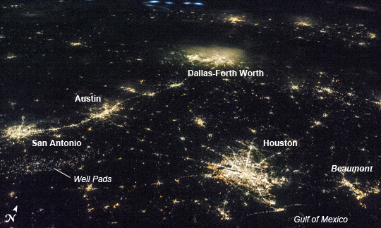 |
| Texas Metropolitan Areas at Night This striking astronaut photograph taken from the International Space Station (ISS) illustrates the four largest metropolitan areas of Texas (by population, using 2010 US Census estimates). The extent of the metropolitan areas is readily visible at night due to city and roadway lighting networks. The largest metro area, Dallas-Fort Worth-Arlington(population over 6.5 million) is visible at image top center; the lighting pattern appears less distinct due to local cloud cover. Four brightly illuminated cloud tops to the northwest (image top center) indicate thunderstorm activity over neighboring Oklahoma. Coming in a close second with a population of approximately 6.1 million, the Houston-Sugar Land-Baytown metro area is located along the Gulf of Mexico coastline at image lower right. To the east near the border with Louisiana, the metropolitan area of Beaumont-Port Arthur ranks tenth (pop. near 400,000) within Texas. Moving inland to south-central Texas, the San Antonio-New Braunfels metro area (image left) has the third largest population of over 2 million. A band of lighting visible to the southeast of San Antonio marks well pads associated with the Eagle Ford Formation (also known as the Eagle Ford Shale); this geologic formation is an important producer of both oil and natural gas. The capital city of Texas (Austin) is included within the Austin-Round Rock-San Marcos metro area to the northeast of San Antonio; it ranks fourth in terms of population with over 1.7 million. The greater Austin metro area is located in central Texas between the Hill Country to the west and the coastal plain to the east-southeast. This image was taken with a relatively high viewing angle from the ISS, as opposed to looking "straight down" towards the Earth's surface as is typical for most orbital remote sensing instruments. Oblique viewing angles tend to change the apparent distance between objects - for a sense of scale, the actual distance between the central Houston and Dallas-Fort Worth metro areas is approximately 367 kilometers (228 miles). |
| Images: | All Available Images Low-Resolution 211k |
|
| Mission: | ISS036 |
|
| Roll - Frame: | E - 9405 |
|
| Geographical Name: | USA-TEXAS |
|
| Features: | HOUSTON AT NIGHT,AUSTIN AT NIGHT,SAN ANTONIO AT NIGHT, STORMS |
|
| Center Lat x Lon: | 30.5N x 96.5W |
|
| Film Exposure: | N=Normal exposure, U=Under exposed, O=Over exposed, F=out of Focus |
|
| Percentage of Cloud Cover-CLDP: | 0 |
|
| Camera:: | N5 |
|
| Camera Tilt: | HO | LO=Low Oblique, HO=High Oblique, NV=Near Vertical |
| Camera Focal Length: | 50 |
|
| Nadir to Photo Center Direction: | N | The direction from the nadir to the center point, N=North, S=South, E=East, W=West |
| Stereo?: | Y=Yes there is an adjacent picture of the same area, N=No there isn't |
|
| Orbit Number: | |
|
| Date: | 20130617 | YYYYMMDD |
| Time: | 062043 | GMT HHMMSS |
| Nadir Lat: | 24.7N |
Latitude of suborbital point of spacecraft |
| Nadir Lon: | 94.1W |
Longitude of suborbital point of spacecraft |
| Sun Azimuth: | 1 | Clockwise angle in degrees from north to the sun measured at the nadir point |
| Space Craft Altitude: | 221 | nautical miles |
| Sun Elevation: | -42 | Angle in degrees between the horizon and the sun, measured at the nadir point |
| Land Views: | PLAIN |
|
| Water Views: | |
|
| Atmosphere Views: | THUNDERSTORM |
|
| Man Made Views: | |
|
| City Views: | ARLINGTON, AUSTIN, BAYTOWN, BEAUMONT, DALLAS, FORT WORTH, HOUSTON |
|
Photo is not associated with any sequences | ||
| NASA Home Page |
JSC Home Page |
JSC Digital Image Collection |
Earth Science & Remote Sensing |
|
This service is provided by the International Space Station program and the JSC Earth Science & Remote Sensing Unit, ARES Division, Exploration Integration Science Directorate.

|