
Geographic Region: ITALY
Feature: LAKE BRACCIANO,LAKE VICO,CAPRANICA,RONCIGLIONE,SUNGLINT
|
Geographic Region: ITALY Feature: LAKE BRACCIANO,LAKE VICO,CAPRANICA,RONCIGLIONE,SUNGLINT |
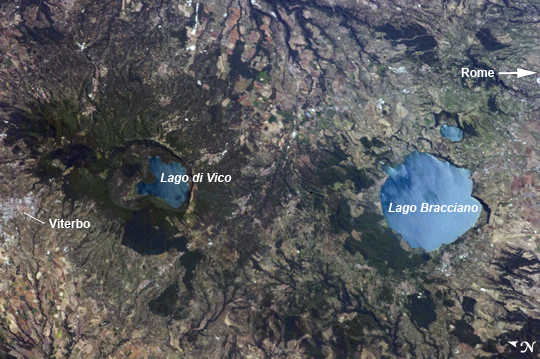 |
| Caldera Lakes to the North of Rome, Italy Note: This caption refers to the image versions labeled "NASA's Earth Observatory web site". The Lazio region of central Italy has many landforms of volcanic origin, including several large lakes that mark the locations of ancient volcanoes. This astronaut photograph from the International Space Station highlights two such lakes, Lago di Vico and Lago Bracciano, located to the northwest of the capital city of Rome. Both lakes are located within calderas, large depressions that form after violent explosive eruptions empty a volcano's underlying magma chamber. Any remnants of the volcanic edifice can then collapse into the newly-formed void space, leading to the creation of large depressions. These depressions can then fill partially or completely with water, forming permanent lakes. Lago Bracciano (image right) is the larger of the two lakes highlighted in the image; it is approximately 8 km wide at its widest point, and is located 32 km northwest of Rome. The volcanic activity that led to the formation of Lago Bracciano began approximately 600,000 years ago and continued to approximately 40,000 years ago as part of the formation of the Sabatini volcanic complex. While part of the lake formation was due to caldera collapse of part of a large magma chamber, the current depression was also formed by movement along numerous faults in the area- a process known as volcano-tectonic collapse. Located approximately 24 km to the north-northwest of Lago Bracciano, Lago di Vico (image left) occupies part of a caldera associated with eruptive activity that began approximately 800,000 years ago and continued until approximately 90,000 years ago. The caldera formed largely by the catastrophic eruption of the ancestral Vico volcano approximately 200,000-150,000 years ago. The final phase of volcanic activity in the caldera led to the formation of a small lava cone in the NE quadrant known as Mount Venus. The extent of the lakes of Bracciano and Vico are readily apparent in this image due to sunglint - light reflecting back towards the observer from the water surfaces. This reflection gives a mirror-like sheen to the water surfaces in the image. Dark green forested areas associated with parks are visible near both lakes, while light gray to white regions indicate built areas - such as the city of Viterbo at image left - and tilled fields (image top center). |
| Images: | All Available Images Low-Resolution 292k |
|
| Mission: | ISS036 |
|
| Roll - Frame: | E - 39778 |
|
| Geographical Name: | ITALY |
|
| Features: | LAKE BRACCIANO,LAKE VICO,CAPRANICA,RONCIGLIONE,SUNGLINT |
|
| Center Lat x Lon: | 42.2N x 12.2E |
|
| Film Exposure: | N=Normal exposure, U=Under exposed, O=Over exposed, F=out of Focus |
|
| Percentage of Cloud Cover-CLDP: | 10 |
|
| Camera:: | N5 |
|
| Camera Tilt: | 26 | LO=Low Oblique, HO=High Oblique, NV=Near Vertical |
| Camera Focal Length: | 400 |
|
| Nadir to Photo Center Direction: | S | The direction from the nadir to the center point, N=North, S=South, E=East, W=West |
| Stereo?: | Y=Yes there is an adjacent picture of the same area, N=No there isn't |
|
| Orbit Number: | |
|
| Date: | 20130903 | YYYYMMDD |
| Time: | 090233 | GMT HHMMSS |
| Nadir Lat: | 44.0N |
Latitude of suborbital point of spacecraft |
| Nadir Lon: | 11.9E |
Longitude of suborbital point of spacecraft |
| Sun Azimuth: | 133 | Clockwise angle in degrees from north to the sun measured at the nadir point |
| Space Craft Altitude: | 220 | nautical miles |
| Sun Elevation: | 44 | Angle in degrees between the horizon and the sun, measured at the nadir point |
| Land Views: | CALDERA, VOLCANO |
|
| Water Views: | LAKE, SUNGLINT |
|
| Atmosphere Views: | |
|
| Man Made Views: | |
|
| City Views: | |
|
Photo is not associated with any sequences | ||
| NASA Home Page |
JSC Home Page |
JSC Digital Image Collection |
Earth Science & Remote Sensing |
|
This service is provided by the International Space Station program and the JSC Earth Science & Remote Sensing Unit, ARES Division, Exploration Integration Science Directorate.

|